Calusco d'Adda night lights from space
Night Light of Calusco d'Adda (Lombardy) from space (Italy) Src. Average luminocity for 10x10km area is 72.0061% and for 50x50km: 61.1586%.
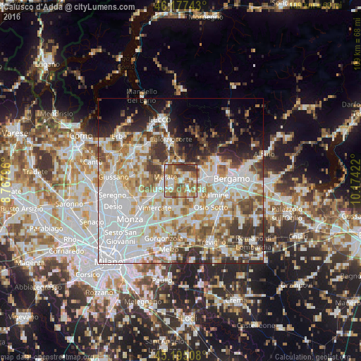
Analysis of Calusco d'Adda night lights 2016
Square area 10x10 km:
 14.39%
90-99
14.7%80-89
8.64%70-79
13.79%60-69
18.48%50-59
14.85%40-49
5.91%30-39
9.24%20-29
0%10-19
0%0-9
0%Square area 50x50 km:
21.02%90-99
13.96%80-89
5.72%70-79
7.45%60-69
7.69%50-59
6.42%40-49
5.86%30-39
6.33%20-29
6.48%10-19
6.76%0-9
12.31%Clear (daylight) street map image can be seen on geolist.org.
Map coordinates:
46° 10' 38.7" North, 8° 46' 4.7" East
45° 41' 18.3" North, 9° 28' 15.9" East
45° 11' 42.3" North, 10° 10' 27.2" East
Some cities around Calusco d'Adda sort by population:
• Merate
3.9 km =2.4 mi,  270°
270°
• Bernareggio
6.8 km =4.2 mi,  228°
228°
• Cornate d'Adda
6.7 km =4.2 mi,  178°
178°
• Terno d'Isola
4.7 km =2.9 mi,  94°
94°
• Bonate Sopra
6.9 km =4.3 mi,  96°
96°
• Olgiate Molgora
7 km =4.3 mi,  311°
311°
• Robbiate
2.6 km =1.6 mi, 269°
• Bottanuco
6.2 km =3.9 mi,  151°
151°
3181165 (p: 8,157)
Sources (retrieved 2019-11-25):
» Earth at Night: Flat Maps 2012, 2016