Olgiate Molgora night lights from space
Night Light of Olgiate Molgora (Lombardy) from space (Italy) Src. Average luminocity for 10x10km area is 59.4136% and for 50x50km: 57.5599%.
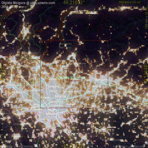
Analysis of Olgiate Molgora night lights 2016
Square area 10x10 km:
 7.88%
7.88%90-99
6.67%80-89
5.91%70-79
11.06%60-69
11.36%50-59
16.06%40-49
17.58%30-39
22.27%20-29
1.21%10-19
0%0-9
0%Square area 50x50 km:
19.93%90-99
13.73%80-89
5.56%70-79
7.44%60-69
7.23%50-59
5.41%40-49
4.69%30-39
4.83%20-29
4.77%10-19
6.93%0-9
19.46%Clear (daylight) street map image can be seen on geolist.org.
Map coordinates:
46° 13' 8.1" North, 8° 42' 0.8" East
45° 43' 49" North, 9° 24' 12.1" East
45° 14' 14.4" North, 10° 6' 23.3" East
Some cities around Olgiate Molgora sort by population:
• Calolziocorte
7.7 km =4.8 mi,  20°
20°
• Merate
4.8 km =3 mi,  163°
163°
• Calusco d'Adda
7 km =4.3 mi,  131°
131°
• Olginate
6.9 km =4.3 mi,  9°
9°
• Casatenovo
8 km =5 mi,  240°
240°
• Robbiate
5.4 km =3.4 mi,  150°
150°
• Missaglia
5.9 km =3.7 mi, 243°
• Barzanò
7 km =4.3 mi,  272°
272°
3180789 (p: 6,311)
Sources (retrieved 2019-11-25):
» Earth at Night: Flat Maps 2012, 2016