Caerano di San Marco night lights from space
Night Light of Caerano di San Marco (Veneto) from space (Italy) Src. Average luminocity for 10x10km area is 45.9508% and for 50x50km: 38.0919%.
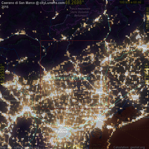
Analysis of Caerano di San Marco night lights 2016
Square area 10x10 km:
 4.29%
4.29%90-99
6.19%80-89
4.92%70-79
5.4%60-69
5.87%50-59
12.06%40-49
12.06%30-39
8.1%20-29
34.6%10-19
6.51%0-9
0%Square area 50x50 km:
3.57%90-99
5.6%80-89
4.12%70-79
4.59%60-69
6.78%50-59
8.98%40-49
9.4%30-39
9.22%20-29
14.04%10-19
12.64%0-9
21.07%Clear (daylight) street map image can be seen on geolist.org.
Map coordinates:
46° 16' 11.3" North, 11° 17' 43.4" East
45° 46' 53.8" North, 11° 59' 54.6" East
45° 17' 20.7" North, 12° 42' 5.9" East
Some cities around Caerano di San Marco sort by population:
• Montebelluna
4 km =2.5 mi,  100°
100°
• Castelfranco Veneto
13.4 km =8.3 mi,  204°
204°
• Col San Martino
16 km =9.9 mi,  34°
34°
• Farra di Soligo
16.9 km =10.5 mi,  35°
35°
• San Zenone degli Ezzelini
12.5 km =7.8 mi,  269°
269°
• Valdobbiadene
12.9 km =8 mi,  354°
354°
• Crocetta del Montello
6.7 km =4.2 mi,  23°
23°
• Cornuda
5.6 km =3.5 mi,  5°
5°
3181284 (p: 7,106)
Sources (retrieved 2019-11-25):
» Earth at Night: Flat Maps 2012, 2016