Crocetta del Montello night lights from space
Night Light of Crocetta del Montello (Veneto) from space (Italy) Src. Average luminocity for 10x10km area is 38.0179% and for 50x50km: 33.5066%.
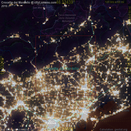
Analysis of Crocetta del Montello night lights 2016
Square area 10x10 km:
 1.64%
1.64%90-99
6.4%80-89
4.17%70-79
3.57%60-69
6.7%50-59
8.04%40-49
5.95%30-39
7.14%20-29
26.19%10-19
29.76%0-9
0.45%Square area 50x50 km:
3.22%90-99
5.12%80-89
3.52%70-79
3.8%60-69
5.82%50-59
7.93%40-49
7.67%30-39
7.33%20-29
12.57%10-19
13.21%0-9
29.81%Clear (daylight) street map image can be seen on geolist.org.
Map coordinates:
46° 19' 27.8" North, 11° 19' 49.8" East
45° 50' 12" North, 12° 2' 1" East
45° 20' 40.7" North, 12° 44' 12.3" East
Some cities around Crocetta del Montello sort by population:
• Montebelluna
7 km =4.3 mi,  170°
170°
• Pieve di Soligo
12.7 km =7.9 mi,  57°
57°
• Col San Martino
9.5 km =5.9 mi,  41°
41°
• Farra di Soligo
10.4 km =6.5 mi, 42°
• Caerano di San Marco
6.7 km =4.2 mi,  203°
203°
• San Zenone degli Ezzelini
16.5 km =10.3 mi,  247°
247°
• Valdobbiadene
7.8 km =4.8 mi,  329°
329°
• Cornuda
2.2 km =1.4 mi,  255°
255°
3177773 (p: 5,709)
Sources (retrieved 2019-11-25):
» Earth at Night: Flat Maps 2012, 2016