Col San Martino night lights from space
Night Light of Col San Martino (Veneto) from space (Italy) Src. Average luminocity for 10x10km area is 32.5327% and for 50x50km: 26.4611%.
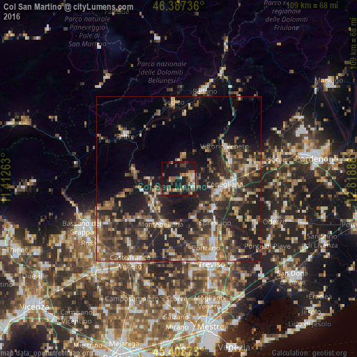
Analysis of Col San Martino night lights 2016
Square area 10x10 km:
 1.79%
1.79%90-99
3.13%80-89
4.91%70-79
3.57%60-69
4.46%50-59
7.29%40-49
8.33%30-39
6.7%20-29
5.51%10-19
42.26%0-9
12.05%Square area 50x50 km:
1.68%90-99
3.53%80-89
2.74%70-79
3.11%60-69
4.34%50-59
5.3%40-49
6.25%30-39
5.96%20-29
12.6%10-19
16.11%0-9
38.37%Clear (daylight) street map image can be seen on geolist.org.
Map coordinates:
46° 23' 14.5" North, 11° 24' 45.5" East
45° 54' 0.7" North, 12° 6' 56.7" East
45° 24' 31.4" North, 12° 49' 8" East
Some cities around Col San Martino sort by population:
• Conegliano
14.5 km =9 mi,  95°
95°
• Pieve di Soligo
4.3 km =2.7 mi,  92°
92°
• Santa Lucia di Piave
14.4 km =8.9 mi,  107°
107°
• Farra di Soligo
0.9 km =0.6 mi,  49°
49°
• Priula-Colfosco
14.2 km =8.8 mi,  128°
128°
• Valdobbiadene
10.3 km =6.4 mi,  267°
267°
• Crocetta del Montello
9.5 km =5.9 mi,  221°
221°
• Cornuda
11.4 km =7.1 mi,  228°
228°
3219783 (p: 8,425)
Sources (retrieved 2019-11-25):
» Earth at Night: Flat Maps 2012, 2016