Bojano night lights from space
Night Light of Bojano (Molise) from space (Italy) Src. Average luminocity for 10x10km area is 12.8844% and for 50x50km: 9.5946%.
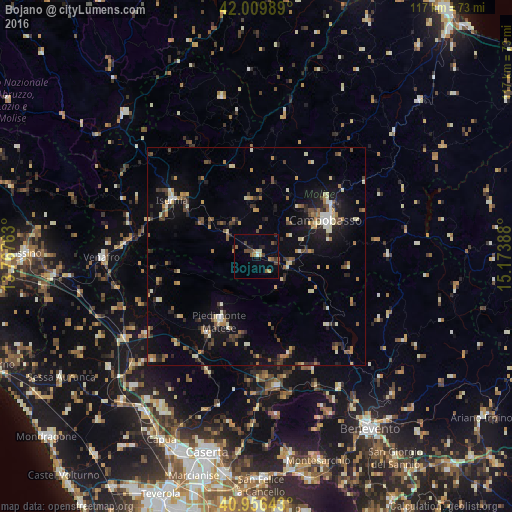
Analysis of Bojano night lights 2016
Square area 10x10 km:
 0%
0%90-99
1.87%80-89
0.51%70-79
2.21%60-69
1.53%50-59
2.72%40-49
3.57%30-39
1.19%20-29
3.23%10-19
2.04%0-9
81.12%Square area 50x50 km:
0.4%90-99
1.45%80-89
0.94%70-79
1.23%60-69
1.39%50-59
1.17%40-49
1.57%30-39
1.43%20-29
2.21%10-19
5.98%0-9
82.22%Clear (daylight) street map image can be seen on geolist.org.
Map coordinates:
42° 0' 35.6" North, 13° 46' 3.5" East
41° 29' 7.1" North, 14° 28' 14.7" East
40° 57' 23.1" North, 15° 10' 26" East
Some cities around Bojano sort by population:
• Campobasso
18.3 km =11.4 mi,  63°
63°
• Isernia
23.2 km =14.4 mi,  301°
301°
• Piedimonte Matese
17.2 km =10.7 mi,  209°
209°
• Venafro
35.2 km =21.9 mi,  269°
269°
• Zuni
41.2 km =25.6 mi,  223°
223°
• Pignataro Maggiore
41.3 km =25.7 mi, 217°
• Calvi Risorta
41.2 km =25.6 mi, 223°
• Telese
30.1 km =18.7 mi,  171°
171°
3181939 (p: 6,014)
Sources (retrieved 2019-11-25):
» Earth at Night: Flat Maps 2012, 2016