Pignataro Maggiore night lights from space
Night Light of Pignataro Maggiore (Campania) from space (Italy) Src. Average luminocity for 10x10km area is 42.2435% and for 50x50km: 28.4615%.
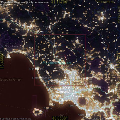
Analysis of Pignataro Maggiore night lights 2016
Square area 10x10 km:
 4.22%
4.22%90-99
10.23%80-89
5.68%70-79
5.19%60-69
3.08%50-59
5.03%40-49
3.9%30-39
7.95%20-29
25.81%10-19
27.76%0-9
1.14%Square area 50x50 km:
3.77%90-99
5.53%80-89
2.84%70-79
3.16%60-69
3.92%50-59
4.37%40-49
3.48%30-39
4.18%20-29
7.34%10-19
22.66%0-9
38.77%Clear (daylight) street map image can be seen on geolist.org.
Map coordinates:
41° 43' 1.3" North, 13° 27' 60" East
41° 11' 24.2" North, 14° 10' 11.2" East
40° 39' 31.7" North, 14° 52' 22.5" East
Some cities around Pignataro Maggiore sort by population:
• Santa Maria Capua Vetere
13.9 km =8.6 mi,  149°
149°
• Capua
10.1 km =6.3 mi,  159°
159°
• Sparanise
6.2 km =3.9 mi,  267°
267°
• Vitulazio
4.7 km =2.9 mi,  129°
129°
• Zuni
4.4 km =2.7 mi,  312°
312°
• Calvi Risorta
4.3 km =2.7 mi, 311°
• Grazzanise
12.6 km =7.8 mi,  208°
208°
• Teano
11 km =6.8 mi, 308°
3170718 (p: 5,783)
Sources (retrieved 2019-11-25):
» Earth at Night: Flat Maps 2012, 2016