Venafro night lights from space
Night Light of Venafro (Molise) from space (Italy) Src. Average luminocity for 10x10km area is 18.0646% and for 50x50km: 13.5598%.
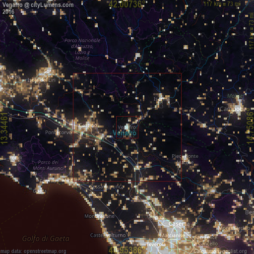
Analysis of Venafro night lights 2016
Square area 10x10 km:
 1.53%
1.53%90-99
2.89%80-89
2.38%70-79
1.02%60-69
1.19%50-59
4.42%40-49
2.55%30-39
2.21%20-29
2.55%10-19
14.12%0-9
65.14%Square area 50x50 km:
0.37%90-99
1.57%80-89
1.38%70-79
1.45%60-69
2.02%50-59
2.52%40-49
2.36%30-39
2.84%20-29
4.32%10-19
10.47%0-9
70.7%Clear (daylight) street map image can be seen on geolist.org.
Map coordinates:
42° 0' 26.5" North, 13° 20' 40.6" East
41° 28' 57.9" North, 14° 2' 51.8" East
40° 57' 13.9" North, 14° 45' 3.1" East
Some cities around Venafro sort by population:
• Cassino
18.3 km =11.4 mi,  271°
271°
• Isernia
20 km =12.4 mi,  50°
50°
• Piedimonte Matese
30.5 km =19 mi,  118°
118°
• Pontecorvo
31.9 km =19.8 mi, 265°
• Zuni
30.3 km =18.8 mi,  166°
166°
• Calvi Risorta
30.5 km =19 mi, 166°
• Sessa Aurunca
28.7 km =17.8 mi,  200°
200°
• Teano
25.8 km =16 mi,  176°
176°
3164621 (p: 9,384)
Sources (retrieved 2019-11-25):
» Earth at Night: Flat Maps 2012, 2016