V.S.K.Valasai (Dindigul-Dist.) night lights from space
Night Light of V.S.K.Valasai (Dindigul-Dist.) (Tamil Nadu) from space (India) Src. Average luminocity for 10x10km area is 0% and for 50x50km: 4.9304%.
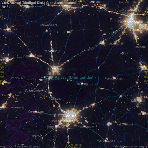
Analysis of V.S.K.Valasai (Dindigul-Dist.) night lights 2016
Square area 10x10 km:
 0%
0%90-99
0%80-89
0%70-79
0%60-69
0%50-59
0%40-49
0%30-39
0%20-29
0%10-19
0%0-9
100%Square area 50x50 km:
0.09%90-99
0.48%80-89
0.58%70-79
0.88%60-69
0.81%50-59
0.61%40-49
1.09%30-39
1.6%20-29
1.64%10-19
2.83%0-9
89.39%Clear (daylight) street map image can be seen on geolist.org.
Map coordinates:
11° 0' 23.3" North, 77° 26' 53.8" East
10° 18' 55.8" North, 78° 9' 5.1" East
9° 37' 22.8" North, 78° 51' 16.3" East
Some cities around V.S.K.Valasai (Dindigul-Dist.) sort by population:
• Dindigul
19.6 km =12.2 mi,  287°
287°
• Vādippatti
33 km =20.5 mi,  219°
219°
• Nattam
13 km =8.1 mi,  138°
138°
• Nilakottai
37 km =23 mi,  243°
243°
• Vadamadurai
15.1 km =9.4 mi,  337°
337°
• Vedasandūr
32.5 km =20.2 mi,  317°
317°
• Alangānallūr
30.6 km =19 mi,  192°
192°
• Pālamedu
23.8 km =14.8 mi, 190°
8948694 (p: 17,865)
Sources (retrieved 2019-11-25):
» Earth at Night: Flat Maps 2012, 2016