Pālamedu night lights from space
Night Light of Pālamedu (Tamil Nadu) from space (India) Src. Average luminocity for 10x10km area is 0.4215% and for 50x50km: 12.3787%.
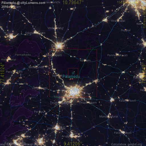
Analysis of Pālamedu night lights 2016
Square area 10x10 km:
 0%
0%90-99
0%80-89
0%70-79
0%60-69
0%50-59
0%40-49
0.83%30-39
0%20-29
0%10-19
0%0-9
99.17%Square area 50x50 km:
1.25%90-99
1.84%80-89
1.47%70-79
2.17%60-69
1.57%50-59
2.15%40-49
1.91%30-39
2.31%20-29
2.89%10-19
6.17%0-9
76.26%Clear (daylight) street map image can be seen on geolist.org.
Map coordinates:
10° 47' 47.3" North, 77° 24' 36.9" East
10° 6' 18" North, 78° 6' 48.1" East
9° 24' 43.4" North, 78° 48' 59.4" East
Some cities around Pālamedu sort by population:
• Madurai
20.7 km =12.9 mi,  178°
178°
• Tirupparangunram
25.2 km =15.7 mi,  190°
190°
• Melur
26 km =16.2 mi,  108°
108°
• Vādippatti
16.8 km =10.4 mi,  262°
262°
• Nattam
18.7 km =11.6 mi,  43°
43°
• Nilakottai
29.6 km =18.4 mi,  283°
283°
• V.S.K.Valasai (Dindigul-Dist.)
23.8 km =14.8 mi,  10°
10°
• Alangānallūr
6.9 km =4.3 mi,  201°
201°
1260786 (p: 8,435)
Sources (retrieved 2019-11-25):
» Earth at Night: Flat Maps 2012, 2016