Thiruvaiyaru night lights from space
Night Light of Thiruvaiyaru (Tamil Nadu) from space (India) Src. Average luminocity for 10x10km area is 6.0346% and for 50x50km: 11.2555%.
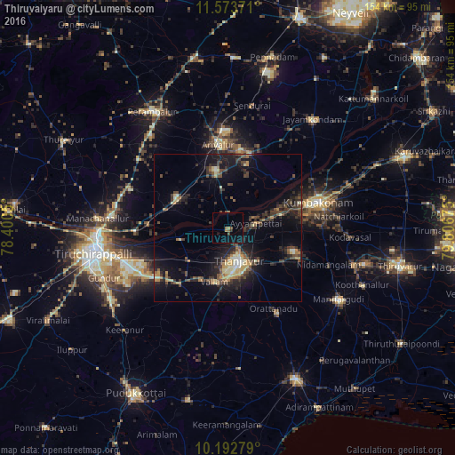
Analysis of Thiruvaiyaru night lights 2016
Square area 10x10 km:
 0%
0%90-99
0%80-89
0%70-79
0.22%60-69
1.73%50-59
1.73%40-49
1.52%30-39
0.65%20-29
0.22%10-19
4.33%0-9
89.61%Square area 50x50 km:
0.17%90-99
1.12%80-89
1.45%70-79
1.4%60-69
1.16%50-59
1.41%40-49
2.69%30-39
3.43%20-29
3.91%10-19
9.05%0-9
74.21%Clear (daylight) street map image can be seen on geolist.org.
Map coordinates:
11° 34' 25.4" North, 78° 24' 1.8" East
10° 53' 2.6" North, 79° 6' 13" East
10° 11' 34" North, 79° 48' 24.3" East
Some cities around Thiruvaiyaru sort by population:
• Tanjore
11.7 km =7.3 mi,  160°
160°
• Ariyalūr
28.5 km =17.7 mi,  353°
353°
• Papanasam
18.8 km =11.7 mi,  75°
75°
• Vallam
18.9 km =11.7 mi,  194°
194°
• Ayyampettāi
8.5 km =5.3 mi, 76°
• Ammāpettai
25.6 km =15.9 mi,  112°
112°
• Pullambādi
22 km =13.7 mi,  286°
286°
• Swāmimalai
26 km =16.2 mi,  71°
71°
1254590 (p: 14,451)
Sources (retrieved 2019-11-25):
» Earth at Night: Flat Maps 2012, 2016