Tāttayyangārpettai night lights from space
Night Light of Tāttayyangārpettai (Tamil Nadu) from space (India) Src. Average luminocity for 10x10km area is 2.0844% and for 50x50km: 5.0527%.
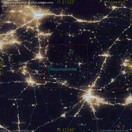
Analysis of Tāttayyangārpettai night lights 2016
Square area 10x10 km:
 0%
0%90-99
0%80-89
0%70-79
0.87%60-69
0.43%50-59
0%40-49
0%30-39
1.3%20-29
1.73%10-19
0.87%0-9
94.81%Square area 50x50 km:
0%90-99
0.18%80-89
0.3%70-79
0.55%60-69
0.75%50-59
0.8%40-49
1.67%30-39
1.71%20-29
2.22%10-19
2.98%0-9
88.85%Clear (daylight) street map image can be seen on geolist.org.
Map coordinates:
11° 48' 47.7" North, 77° 44' 45.7" East
11° 7' 27" North, 78° 26' 57" East
10° 26' 0.5" North, 79° 9' 8.2" East
Some cities around Tāttayyangārpettai sort by population:
• Turaiyūr
16.6 km =10.3 mi,  80°
80°
• Musiri
19 km =11.8 mi,  181°
181°
• Kulittalai
21.4 km =13.3 mi,  190°
190°
• Kāttupputtūr
29 km =18 mi,  239°
239°
• Mettuppālaiyam
4.9 km =3 mi,  0°
0°
• Erumaippatti
17.5 km =10.9 mi,  278°
278°
• Puduppatti
26.1 km =16.2 mi, 276°
• Uppiliyapuram
17 km =10.6 mi,  24°
24°
1254842 (p: 12,604)
Sources (retrieved 2019-11-25):
» Earth at Night: Flat Maps 2012, 2016