Uppiliyapuram night lights from space
Night Light of Uppiliyapuram (Tamil Nadu) from space (India) Src. Average luminocity for 10x10km area is 5.0238% and for 50x50km: 2.501%.
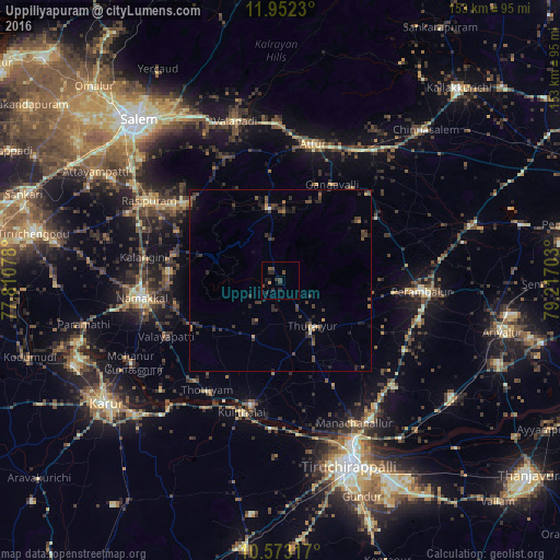
Analysis of Uppiliyapuram night lights 2016
Square area 10x10 km:
 0%
0%90-99
0%80-89
0%70-79
0.87%60-69
0%50-59
0.87%40-49
2.6%30-39
2.6%20-29
3.68%10-19
2.38%0-9
87.01%Square area 50x50 km:
0%90-99
0.09%80-89
0.13%70-79
0.24%60-69
0.2%50-59
0.39%40-49
0.88%30-39
1.18%20-29
1.33%10-19
1.16%0-9
94.39%Clear (daylight) street map image can be seen on geolist.org.
Map coordinates:
11° 57' 8.3" North, 77° 48' 38.8" East
11° 15' 48.8" North, 78° 30' 50" East
10° 34' 23.4" North, 79° 13' 1.3" East
Some cities around Uppiliyapuram sort by population:
• Turaiyūr
15.7 km =9.8 mi,  143°
143°
• Nāmagiripettai
34.2 km =21.3 mi,  308°
308°
• Tāttayyangārpettai
17 km =10.6 mi,  204°
204°
• Arumbāvūr
26.9 km =16.7 mi,  60°
60°
• Gangavalli
30 km =18.6 mi,  29°
29°
• Vīraganūr
33.8 km =21 mi,  45°
45°
• Mettuppālaiyam
12.7 km =7.9 mi,  213°
213°
• Erumaippatti
27.7 km =17.2 mi,  241°
241°
1253719 (p: 6,900)
Sources (retrieved 2019-11-25):
» Earth at Night: Flat Maps 2012, 2016