Kāttupputtūr night lights from space
Night Light of Kāttupputtūr (Tamil Nadu) from space (India) Src. Average luminocity for 10x10km area is 9.7468% and for 50x50km: 11.7553%.
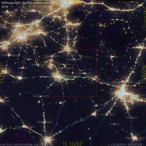
Analysis of Kāttupputtūr night lights 2016
Square area 10x10 km:
 0%
0%90-99
0%80-89
0.87%70-79
1.52%60-69
0.65%50-59
0.87%40-49
3.03%30-39
3.25%20-29
4.55%10-19
5.19%0-9
80.09%Square area 50x50 km:
0.1%90-99
0.94%80-89
1.58%70-79
2.07%60-69
1.7%50-59
2.18%40-49
2.56%30-39
2.91%20-29
4.54%10-19
8.12%0-9
73.3%Clear (daylight) street map image can be seen on geolist.org.
Map coordinates:
11° 40' 59.7" North, 77° 30' 58.2" East
10° 59' 37.9" North, 78° 13' 9.4" East
10° 18' 10.2" North, 78° 55' 20.7" East
Some cities around Kāttupputtūr sort by population:
• Karur
15.6 km =9.7 mi,  255°
255°
• Nāmakkal
26 km =16.2 mi,  346°
346°
• Musiri
25 km =15.5 mi,  100°
100°
• Kulittalai
22.1 km =13.7 mi,  107°
107°
• Velur
27 km =16.8 mi,  298°
298°
• Mohanūr
11.3 km =7 mi,  309°
309°
• Erumaippatti
18.7 km =11.6 mi,  24°
24°
• Puduppatti
17.6 km =10.9 mi,  357°
357°
1267428 (p: 11,040)
Sources (retrieved 2019-11-25):
» Earth at Night: Flat Maps 2012, 2016