Poonamalle night lights from space
Night Light of Poonamalle (Tamil Nadu) from space (India) Src. Average luminocity for 10x10km area is 95.4221% and for 50x50km: 70.1889%.
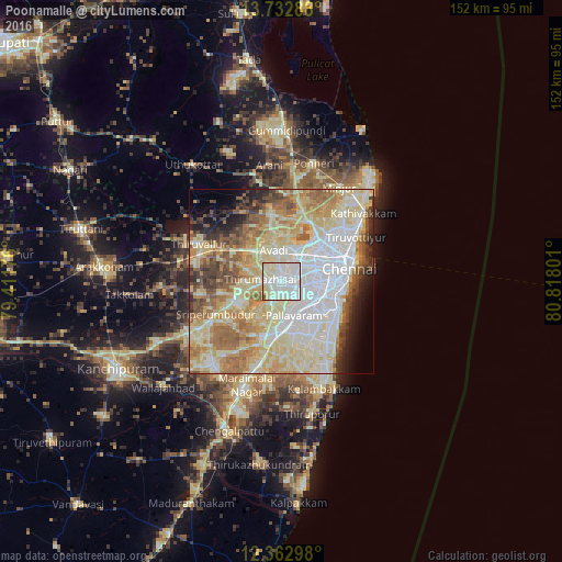
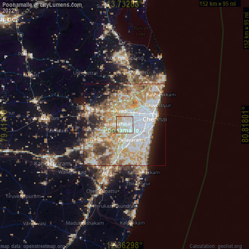
Analysis of Poonamalle night lights 2016
Square area 10x10 km:
 39.61%
90-99
42.86%80-89
15.8%70-79
0.87%60-69
0%50-59
0.87%40-49
0%30-39
0%20-29
0%10-19
0%0-9
0%Square area 50x50 km:
16.82%90-99
18.17%80-89
18.9%70-79
6.75%60-69
9.13%50-59
7.65%40-49
4.59%30-39
3.98%20-29
3.64%10-19
3.76%0-9
6.59%Clear (daylight) street map image can be seen on geolist.org.
Map coordinates:
13° 43' 58.4" North, 79° 24' 42.3" East
13° 2' 56" North, 80° 6' 53.6" East
12° 21' 46.7" North, 80° 49' 4.8" East
Some cities around Poonamalle sort by population:
• Ambattūr
7.5 km =4.7 mi,  42°
42°
• Āvadi
7.3 km =4.5 mi,  355°
355°
• Pallāvaram
9.8 km =6.1 mi,  156°
156°
• Alandur
11.1 km =6.9 mi,  117°
117°
• Saint Thomas Mount
10.2 km =6.3 mi, 119°
• Porur
4.9 km =3 mi,  107°
107°
• Manappakkam
7.2 km =4.5 mi,  126°
126°
• Nandambakkam
9.4 km =5.8 mi,  212°
212°
1259400 (p: 48,837)
Sources (retrieved 2019-11-25):
» Earth at Night: Flat Maps 2012, 2016