Vandalūr night lights from space
Night Light of Vandalūr (Tamil Nadu) from space (India) Src. Average luminocity for 10x10km area is 85.9264% and for 50x50km: 63.0873%.
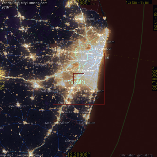
Analysis of Vandalūr night lights 2016
Square area 10x10 km:
 8.87%
8.87%90-99
26.62%80-89
46.97%70-79
10.82%60-69
6.71%50-59
0%40-49
0%30-39
0%20-29
0%10-19
0%0-9
0%Square area 50x50 km:
13.63%90-99
15.39%80-89
15.57%70-79
5.62%60-69
8.88%50-59
7.71%40-49
6.24%30-39
5.44%20-29
6.81%10-19
7.14%0-9
7.57%Clear (daylight) street map image can be seen on geolist.org.
Map coordinates:
13° 34' 36.7" North, 79° 22' 39.6" East
12° 53' 32.6" North, 80° 4' 50.8" East
12° 12' 21.9" North, 80° 47' 2.1" East
Some cities around Vandalūr sort by population:
• Tambaram
6.2 km =3.9 mi,  54°
54°
• Pallāvaram
11.3 km =7 mi,  41°
41°
• Gūduvāncheri
5.7 km =3.5 mi,  202°
202°
• Madambakkam
5.8 km =3.6 mi,  219°
219°
• Madipakkam
14.9 km =9.3 mi,  58°
58°
• Manappakkam
16.2 km =10.1 mi, 35°
• Nandambakkam
9.6 km =6 mi,  351°
351°
• Singapperumālkovil
16.8 km =10.4 mi,  208°
208°
1253454 (p: 13,715)
Sources (retrieved 2019-11-25):
» Earth at Night: Flat Maps 2012, 2016