Shirhatti night lights from space
Night Light of Shirhatti (Karnataka) from space (India) Src. Average luminocity for 10x10km area is 8.7459% and for 50x50km: 5.6683%.
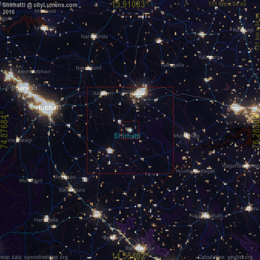
Analysis of Shirhatti night lights 2016
Square area 10x10 km:
 0.83%
0.83%90-99
0.83%80-89
0%70-79
1.03%60-69
1.24%50-59
2.69%40-49
1.65%30-39
2.27%20-29
1.86%10-19
0.83%0-9
86.78%Square area 50x50 km:
0.59%90-99
1.12%80-89
0.39%70-79
0.45%60-69
0.72%50-59
0.85%40-49
0.79%30-39
1.31%20-29
1.33%10-19
2.69%0-9
89.77%Clear (daylight) street map image can be seen on geolist.org.
Map coordinates:
15° 54' 39" North, 74° 52' 36.6" East
15° 14' 0.7" North, 75° 34' 47.9" East
14° 33' 14.5" North, 76° 16' 59.1" East
Some cities around Shirhatti sort by population:
• Gadag-Betageri
20.7 km =12.9 mi,  10°
10°
• Gadag
22.5 km =14 mi, 13°
• Savanūr
38.9 km =24.2 mi,  222°
222°
• Lakshmeshwar
16.8 km =10.4 mi,  225°
225°
• Annigeri
26.5 km =16.5 mi,  323°
323°
• Mundargi
32.7 km =20.3 mi,  95°
95°
• Mulgund
8.2 km =5.1 mi,  309°
309°
• Kundgol
35.8 km =22.2 mi,  274°
274°
1256483 (p: 16,604)
Sources (retrieved 2019-11-25):
» Earth at Night: Flat Maps 2012, 2016