Shāhpur night lights from space
Night Light of Shāhpur (Madhya Pradesh) from space (India) Src. Average luminocity for 10x10km area is 16.631% and for 50x50km: 12.8122%.
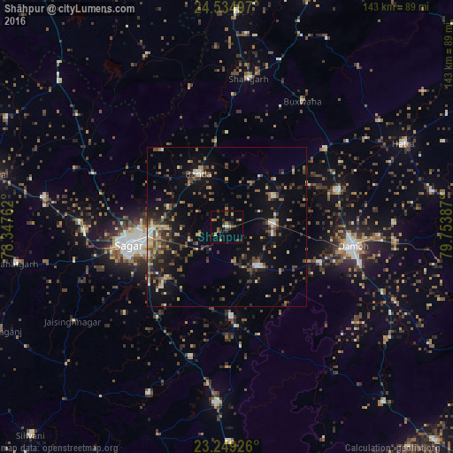
Analysis of Shāhpur night lights 2016
Square area 10x10 km:
 0%
0%90-99
0.79%80-89
2.38%70-79
1.98%60-69
3.57%50-59
2.98%40-49
2.18%30-39
5.95%20-29
5.16%10-19
3.37%0-9
71.63%Square area 50x50 km:
0.61%90-99
1.16%80-89
1.22%70-79
1.11%60-69
2.06%50-59
2.11%40-49
2.95%30-39
2.77%20-29
3.61%10-19
9.83%0-9
72.57%Clear (daylight) street map image can be seen on geolist.org.
Map coordinates:
24° 32' 5.9" North, 78° 20' 51.4" East
23° 53' 37.4" North, 79° 3' 2.7" East
23° 14' 57.3" North, 79° 45' 13.9" East
Some cities around Shāhpur sort by population:
• Saugor
32.3 km =20.1 mi,  259°
259°
• Damoh
40.3 km =25 mi,  99°
99°
• Banda
19.1 km =11.9 mi,  331°
331°
• Garhākota
15.8 km =9.8 mi,  143°
143°
• Rehli
28.5 km =17.7 mi,  177°
177°
• Patharia
14.6 km =9.1 mi,  87°
87°
• Dhāna
25.2 km =15.7 mi,  229°
229°
• Karrāpur
19.8 km =12.3 mi,  288°
288°
1256716 (p: 13,066)
Sources (retrieved 2019-11-25):
» Earth at Night: Flat Maps 2012, 2016