Sāsni night lights from space
Night Light of Sāsni (Uttar Pradesh) from space (India) Src. Average luminocity for 10x10km area is 27.6389% and for 50x50km: 21.4924%.
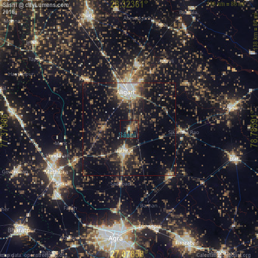
Analysis of Sāsni night lights 2016
Square area 10x10 km:
 0.79%
0.79%90-99
0.79%80-89
0.79%70-79
3.37%60-69
6.35%50-59
8.33%40-49
7.74%30-39
6.75%20-29
7.74%10-19
40.48%0-9
16.87%Square area 50x50 km:
1.2%90-99
2.33%80-89
1.75%70-79
1.36%60-69
2.74%50-59
4.46%40-49
5.78%30-39
6.28%20-29
8.5%10-19
18.19%0-9
47.43%Clear (daylight) street map image can be seen on geolist.org.
Map coordinates:
28° 19' 25" North, 77° 22' 46.8" East
27° 42' 10.3" North, 78° 4' 58" East
27° 4' 42.9" North, 78° 47' 9.3" East
Some cities around Sāsni sort by population:
• Alīgarh
19.9 km =12.4 mi,  357°
357°
• Hāthras
12.3 km =7.6 mi,  194°
194°
• Sikandra Rao
29.3 km =18.2 mi,  93°
93°
• Jalālī
24.7 km =15.3 mi,  42°
42°
• Iglās
14.1 km =8.8 mi,  273°
273°
• Harduāganj
27.8 km =17.3 mi,  15°
15°
• Mursān
19.7 km =12.2 mi,  225°
225°
• Beswān
21.2 km =13.2 mi,  250°
250°
1257077 (p: 13,498)
Sources (retrieved 2019-11-25):
» Earth at Night: Flat Maps 2012, 2016