Iglās night lights from space
Night Light of Iglās (Uttar Pradesh) from space (India) Src. Average luminocity for 10x10km area is 27.9048% and for 50x50km: 23.4034%.
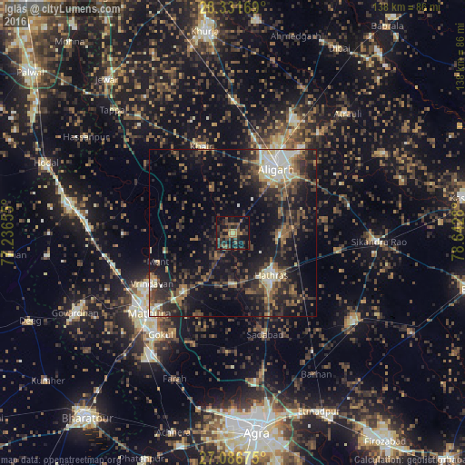
Analysis of Iglās night lights 2016
Square area 10x10 km:
 0%
0%90-99
0%80-89
1.19%70-79
2.58%60-69
3.77%50-59
10.32%40-49
10.32%30-39
11.9%20-29
10.71%10-19
33.53%0-9
15.67%Square area 50x50 km:
1.54%90-99
2.8%80-89
2.38%70-79
1.54%60-69
3.03%50-59
4.78%40-49
5.65%30-39
6.45%20-29
9.48%10-19
20%0-9
42.34%Clear (daylight) street map image can be seen on geolist.org.
Map coordinates:
28° 19' 54.1" North, 77° 14' 11.6" East
27° 42' 39.6" North, 77° 56' 22.8" East
27° 5' 12.3" North, 78° 38' 34.1" East
Some cities around Iglās sort by population:
• Alīgarh
23.1 km =14.4 mi,  35°
35°
• Hāthras
17 km =10.6 mi,  139°
139°
• Vrindāvan
28 km =17.4 mi,  238°
238°
• Khair
27.4 km =17 mi,  339°
339°
• Rāya
22.7 km =14.1 mi,  220°
220°
• Sāsni
14.1 km =8.8 mi,  93°
93°
• Mursān
14.8 km =9.2 mi,  179°
179°
• Beswān
10 km =6.2 mi, 215°
1269809 (p: 13,746)
Sources (retrieved 2019-11-25):
» Earth at Night: Flat Maps 2012, 2016