Saidpur night lights from space
Night Light of Saidpur (Uttar Pradesh) from space (India) Src. Average luminocity for 10x10km area is 27.2083% and for 50x50km: 32.6424%.
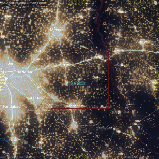
Analysis of Saidpur night lights 2016
Square area 10x10 km:
 0%
0%90-99
0.76%80-89
0%70-79
0.76%60-69
3.98%50-59
7.39%40-49
14.77%30-39
7.58%20-29
14.96%10-19
49.24%0-9
0.57%Square area 50x50 km:
1.67%90-99
3.29%80-89
3.27%70-79
3.27%60-69
5.11%50-59
7.44%40-49
9.37%30-39
9.44%20-29
14.76%10-19
24.25%0-9
18.12%Clear (daylight) street map image can be seen on geolist.org.
Map coordinates:
29° 13' 34.8" North, 77° 12' 21" East
28° 36' 39.2" North, 77° 54' 32.3" East
27° 59' 30.6" North, 78° 36' 43.5" East
Some cities around Saidpur sort by population:
• Hāpur
18.2 km =11.3 mi,  316°
316°
• Bulandshahr
23.6 km =14.7 mi,  192°
192°
• Pilkhua
27.2 km =16.9 mi,  294°
294°
• Sikandarābād
27 km =16.8 mi,  229°
229°
• Gulāothi
11.6 km =7.2 mi,  258°
258°
• Garhmuktesar
27.2 km =16.9 mi,  43°
43°
• Khānpur
17.5 km =10.9 mi,  119°
119°
• Babugarh
13.9 km =8.6 mi,  334°
334°
1257775 (p: 14,496)
Sources (retrieved 2019-11-25):
» Earth at Night: Flat Maps 2012, 2016