Sabrūm night lights from space
Night Light of Sabrūm (Tripura) from space (India) Src. Average luminocity for 10x10km area is 10.3552% and for 50x50km: 2.5812%.
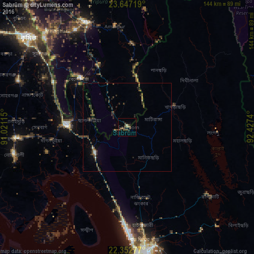
Analysis of Sabrūm night lights 2016
Square area 10x10 km:
 0%
0%90-99
0.79%80-89
0.79%70-79
0.79%60-69
0.79%50-59
1.79%40-49
8.13%30-39
0.79%20-29
1.98%10-19
4.37%0-9
79.76%Square area 50x50 km:
0.09%90-99
0.16%80-89
0.06%70-79
0.15%60-69
0.26%50-59
0.59%40-49
1.16%30-39
0.68%20-29
1.06%10-19
0.77%0-9
95.02%Clear (daylight) street map image can be seen on geolist.org.
Map coordinates:
23° 38' 49.9" North, 91° 1' 16.1" East
23° 0' 5.5" North, 91° 43' 27.4" East
22° 21' 10" North, 92° 25' 38.6" East
Some cities around Sabrūm sort by population:
• Bibir Hat, BD
36 km =22.4 mi,  169°
169°
• Feni, BD
33.6 km =20.9 mi,  272°
272°
• Khagrachhari, BD
27.8 km =17.3 mi,  64°
64°
• Chhāgalnāiya, BD
22 km =13.7 mi,  276°
276°
• Raojān, BD
55.6 km =34.5 mi,  158°
158°
• Manikchari, BD
21.6 km =13.4 mi,  146°
146°
• Belonia
39.2 km =24.4 mi,  315°
315°
• Amarpur
58.7 km =36.5 mi,  353°
353°
1257908 (p: 6,205)
Sources (retrieved 2019-11-25):
» Earth at Night: Flat Maps 2012, 2016