Rāmnagar night lights from space
Night Light of Rāmnagar (West Bengal) from space (India) Src. Average luminocity for 10x10km area is 73.6587% and for 50x50km: 61.859%.
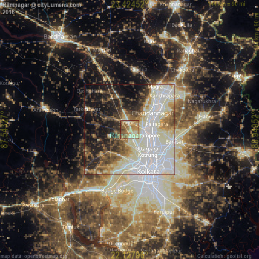
Analysis of Rāmnagar night lights 2016
Square area 10x10 km:
 1.19%
1.19%90-99
20.63%80-89
19.84%70-79
19.25%60-69
16.27%50-59
14.48%40-49
7.14%30-39
1.19%20-29
0%10-19
0%0-9
0%Square area 50x50 km:
18.15%90-99
20.35%80-89
5.52%70-79
4.55%60-69
5.32%50-59
6.21%40-49
6.71%30-39
6.35%20-29
8.7%10-19
13.33%0-9
4.81%Clear (daylight) street map image can be seen on geolist.org.
Map coordinates:
23° 25' 28.3" North, 87° 32' 35.8" East
22° 46' 40" North, 88° 14' 47" East
22° 7' 40.7" North, 88° 56' 58.3" East
Some cities around Rāmnagar sort by population:
• Shrīrāmpur
10.2 km =6.3 mi,  105°
105°
• Bārākpur
12.1 km =7.5 mi,  96°
96°
• Bhadreswar
10.8 km =6.7 mi,  61°
61°
• Rishra
11.8 km =7.3 mi,  120°
120°
• Baidyabāti
8.2 km =5.1 mi,  84°
84°
• Singur
3.9 km =2.4 mi,  333°
333°
• Begampur
5.4 km =3.4 mi,  167°
167°
• Gangadharpur
3.4 km =2.1 mi,  233°
233°
1348671 (p: 5,195)
Sources (retrieved 2019-11-25):
» Earth at Night: Flat Maps 2012, 2016