Gangadharpur night lights from space
Night Light of Gangadharpur (West Bengal) from space (India) Src. Average luminocity for 10x10km area is 63.6845% and for 50x50km: 60.3702%.
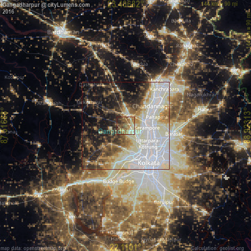
Analysis of Gangadharpur night lights 2016
Square area 10x10 km:
 1.59%
1.59%90-99
14.48%80-89
10.32%70-79
11.9%60-69
18.06%50-59
16.87%40-49
13.49%30-39
5.56%20-29
7.74%10-19
0%0-9
0%Square area 50x50 km:
18.03%90-99
18.84%80-89
5.27%70-79
4.36%60-69
5.16%50-59
6.12%40-49
7.06%30-39
6.98%20-29
9.42%10-19
13.3%0-9
5.46%Clear (daylight) street map image can be seen on geolist.org.
Map coordinates:
23° 24' 24.6" North, 87° 31' 0.8" East
22° 45' 36" North, 88° 13' 12" East
22° 6' 36.4" North, 88° 55' 23.3" East
Some cities around Gangadharpur sort by population:
• Shrīrāmpur
12.6 km =7.8 mi,  93°
93°
• Rishra
13.5 km =8.4 mi,  107°
107°
• Baidyabāti
11.2 km =7 mi,  75°
75°
• Singur
5.6 km =3.5 mi,  10°
10°
• Begampur
5.1 km =3.2 mi,  130°
130°
• Parbatipur
10.8 km =6.7 mi,  178°
178°
• Krishnapur
11.2 km =7 mi,  153°
153°
• Rāmnagar
3.4 km =2.1 mi,  53°
53°
8985894 (p: 7,862)
Sources (retrieved 2019-11-25):
» Earth at Night: Flat Maps 2012, 2016