Rādhākund night lights from space
Night Light of Rādhākund (Uttar Pradesh) from space (India) Src. Average luminocity for 10x10km area is 35.2917% and for 50x50km: 16.844%.
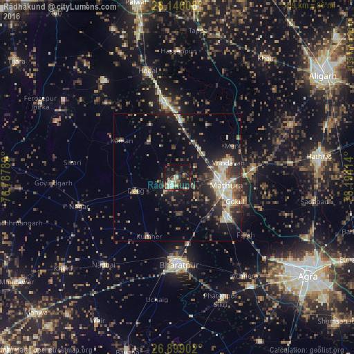
Analysis of Rādhākund night lights 2016
Square area 10x10 km:
 4.37%
4.37%90-99
5.16%80-89
7.14%70-79
1.59%60-69
4.96%50-59
4.56%40-49
2.78%30-39
7.34%20-29
11.11%10-19
40.28%0-9
10.71%Square area 50x50 km:
1.59%90-99
2.73%80-89
2.76%70-79
1.21%60-69
1.39%50-59
2.37%40-49
3.06%30-39
3.65%20-29
5.83%10-19
12.72%0-9
62.69%Clear (daylight) street map image can be seen on geolist.org.
Map coordinates:
28° 8' 45.9" North, 76° 47' 16.4" East
27° 31' 27.6" North, 77° 29' 27.6" East
26° 53' 56.5" North, 78° 11' 38.9" East
Some cities around Rādhākund sort by population:
• Mathura
18 km =11.2 mi,  97°
97°
• Vrindāvan
21.2 km =13.2 mi,  72°
72°
• Dīg
17.3 km =10.7 mi,  250°
250°
• Kūmher
26 km =16.2 mi,  207°
207°
• Chhāta
22.2 km =13.8 mi,  4°
4°
• Govardhan
4.2 km =2.6 mi,  222°
222°
• Nandgaon
23.2 km =14.4 mi,  333°
333°
• Barsāna
17.8 km =11.1 mi,  320°
320°
1259072 (p: 6,420)
Sources (retrieved 2019-11-25):
» Earth at Night: Flat Maps 2012, 2016