Qādiān night lights from space
Night Light of Qādiān (Punjab) from space (India) Src. Average luminocity for 10x10km area is 18.4469% and for 50x50km: 14.1832%.

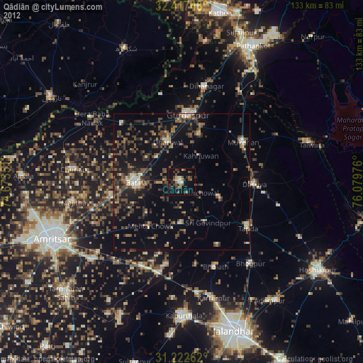
Analysis of Qādiān night lights 2016
Square area 10x10 km:
 0.92%
0.92%90-99
2.01%80-89
1.28%70-79
0.18%60-69
1.47%50-59
4.21%40-49
3.66%30-39
5.68%20-29
6.59%10-19
16.12%0-9
57.88%Square area 50x50 km:
0.63%90-99
1.92%80-89
0.87%70-79
0.73%60-69
1.48%50-59
2.65%40-49
3.54%30-39
4.03%20-29
5.46%10-19
11.81%0-9
66.86%Clear (daylight) street map image can be seen on geolist.org.
Map coordinates:
32° 25' 2.9" North, 74° 40' 24.6" East
31° 49' 19.1" North, 75° 22' 35.9" East
31° 13' 21.4" North, 76° 4' 47.1" East
Some cities around Qādiān sort by population:
• Batāla
16.5 km =10.3 mi,  265°
265°
• Mukeriān
27 km =16.8 mi,  57°
57°
• Dasūya
26.1 km =16.2 mi,  91°
91°
• Dhāriwāl
15.7 km =9.8 mi,  341°
341°
• Kalanaur
30 km =18.6 mi,  314°
314°
• Bhulath Gharbi
33.4 km =20.8 mi,  158°
158°
• Begowāl
27.1 km =16.8 mi,  149°
149°
• Dhilwan
34.3 km =21.3 mi,  184°
184°
1259110 (p: 21,015)
Sources (retrieved 2019-11-25):
» Earth at Night: Flat Maps 2012, 2016