Punjai Puliyampatti night lights from space
Night Light of Punjai Puliyampatti (Tamil Nadu) from space (India) Src. Average luminocity for 10x10km area is 7.4589% and for 50x50km: 17.9797%.
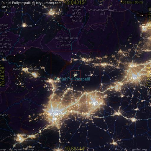
Analysis of Punjai Puliyampatti night lights 2016
Square area 10x10 km:
 0%
0%90-99
0%80-89
1.3%70-79
1.3%60-69
0.87%50-59
1.73%40-49
1.08%30-39
2.81%20-29
3.25%10-19
3.03%0-9
84.63%Square area 50x50 km:
0.15%90-99
1.23%80-89
2.48%70-79
3.11%60-69
3.12%50-59
3.92%40-49
5.74%30-39
5.61%20-29
5.6%10-19
9.56%0-9
59.48%Clear (daylight) street map image can be seen on geolist.org.
Map coordinates:
12° 2' 24.5" North, 76° 27' 48.9" East
11° 21' 5.9" North, 77° 10' 0.2" East
10° 39' 41.2" North, 77° 52' 11.4" East
Some cities around Punjai Puliyampatti sort by population:
• Mettupalayam
25.9 km =16.1 mi,  257°
257°
• Gobichettipalayam
32.1 km =19.9 mi,  69°
69°
• Sathyamangalam
18.8 km =11.7 mi,  24°
24°
• Kāramadai
25.7 km =16 mi,  241°
241°
• Avinashi
20.9 km =13 mi,  147°
147°
• Sirumugai
17.9 km =11.1 mi, 259°
• Annur
14.5 km =9 mi,  207°
207°
• Nambiyūr
16.9 km =10.5 mi,  87°
87°
1259222 (p: 15,066)
Sources (retrieved 2019-11-25):
» Earth at Night: Flat Maps 2012, 2016