Kāramadai night lights from space
Night Light of Kāramadai (Tamil Nadu) from space (India) Src. Average luminocity for 10x10km area is 38.4481% and for 50x50km: 25.209%.
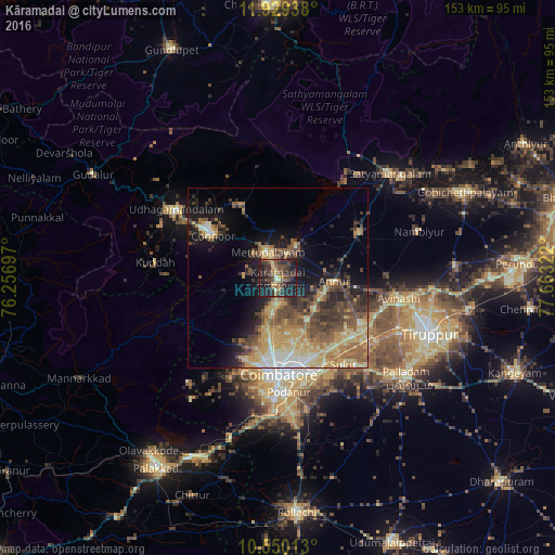

Analysis of Kāramadai night lights 2016
Square area 10x10 km:
 0.43%
0.43%90-99
2.16%80-89
1.95%70-79
6.71%60-69
7.58%50-59
8.44%40-49
13.42%30-39
16.23%20-29
22.29%10-19
20.78%0-9
0%Square area 50x50 km:
1.57%90-99
2.85%80-89
4.97%70-79
5.29%60-69
4.07%50-59
4.89%40-49
5.25%30-39
4.72%20-29
5.27%10-19
9.79%0-9
51.32%Clear (daylight) street map image can be seen on geolist.org.
Map coordinates:
11° 55' 45.8" North, 76° 15' 25.1" East
11° 14' 26.1" North, 76° 57' 36.3" East
10° 33' 0.5" North, 77° 39' 47.6" East
Some cities around Kāramadai sort by population:
• Mettupalayam
7.1 km =4.4 mi,  337°
337°
• Kotagiri
22.8 km =14.2 mi,  331°
331°
• Periyanayakkanpalaiyam
9.8 km =6.1 mi,  185°
185°
• Wellington
23.7 km =14.7 mi,  305°
305°
• Sirumugai
10.2 km =6.3 mi,  28°
28°
• Annur
15.8 km =9.8 mi,  91°
91°
• Punjai Puliyampatti
25.7 km =16 mi,  61°
61°
• Aruvankad
25.9 km =16.1 mi,  301°
301°
1267869 (p: 31,188)
Sources (retrieved 2019-11-25):
» Earth at Night: Flat Maps 2012, 2016