Parvatsar night lights from space
Night Light of Parvatsar (Rajasthan) from space (India) Src. Average luminocity for 10x10km area is 11.8373% and for 50x50km: 5.0036%.
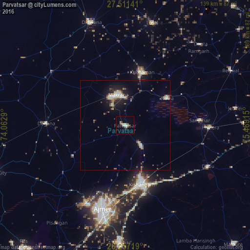
Analysis of Parvatsar night lights 2016
Square area 10x10 km:
 0.79%
0.79%90-99
3.17%80-89
0.6%70-79
1.79%60-69
1.59%50-59
0.99%40-49
2.18%30-39
2.38%20-29
0%10-19
1.59%0-9
84.92%Square area 50x50 km:
0.38%90-99
0.88%80-89
0.7%70-79
0.28%60-69
0.47%50-59
0.7%40-49
1.01%30-39
0.72%20-29
1.16%10-19
3.38%0-9
90.33%Clear (daylight) street map image can be seen on geolist.org.
Map coordinates:
27° 30' 41.1" North, 74° 3' 46.4" East
26° 53' 9.7" North, 74° 45' 57.7" East
26° 15' 25.9" North, 75° 28' 8.9" East
Some cities around Parvatsar sort by population:
• Kishangarh
34 km =21.1 mi,  165°
165°
• Makrāna
18 km =11.2 mi,  346°
346°
• Kuchāman
30.4 km =18.9 mi,  17°
17°
• Sāmbhar
42.2 km =26.2 mi,  86°
86°
• Phulera
47.2 km =29.3 mi, 91°
• Nāwa
27.7 km =17.2 mi,  57°
57°
• Naraina
44.9 km =27.9 mi,  103°
103°
• Pushkar
48.9 km =30.4 mi,  205°
205°
1260221 (p: 15,405)
Sources (retrieved 2019-11-25):
» Earth at Night: Flat Maps 2012, 2016