Pānchgani night lights from space
Night Light of Pānchgani (Maharashtra) from space (India) Src. Average luminocity for 10x10km area is 15.2662% and for 50x50km: 5.5209%.
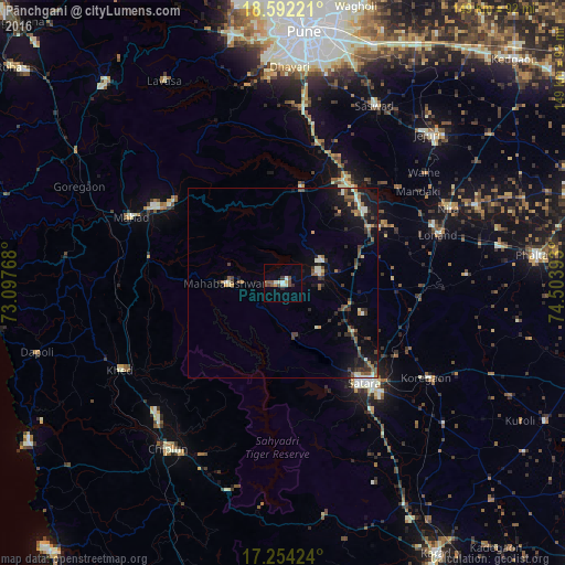
Analysis of Pānchgani night lights 2016
Square area 10x10 km:
100  0.65%
0.65%
90-99 4.55%
80-89 0.65%
70-79 1.08%
60-69 0.22%
50-59 5.41%
40-49 2.81%
30-39 1.52%
20-29 1.3%
10-19 0.87%
0-9 80.95%
0.65%90-99
4.55%80-89
0.65%70-79
1.08%60-69
0.22%50-59
5.41%40-49
2.81%30-39
1.52%20-29
1.3%10-19
0.87%0-9
80.95%Square area 50x50 km:
100 0.07%
90-99 1.12%
80-89 0.34%
70-79 0.43%
60-69 0.57%
50-59 1.22%
40-49 0.9%
30-39 1.39%
20-29 1.39%
10-19 3.92%
0-9 88.66%
0.07%90-99
1.12%80-89
0.34%70-79
0.43%60-69
0.57%50-59
1.22%40-49
0.9%30-39
1.39%20-29
1.39%10-19
3.92%0-9
88.66%Clear (daylight) street map image can be seen on geolist.org.
Map coordinates:
18° 35' 32" North, 73° 5' 51.6" East
17° 55' 28.2" North, 73° 48' 2.9" East
17° 15' 15.3" North, 74° 30' 14.1" East
Some cities around Pānchgani sort by population:
• Satara
33.5 km =20.8 mi,  142°
142°
• Wai
10 km =6.2 mi,  71°
71°
• Sāsvad
52.6 km =32.7 mi,  27°
27°
• Mahād
44.3 km =27.5 mi,  293°
293°
• Bhor
25.3 km =15.7 mi,  10°
10°
• Khed
48.5 km =30.1 mi,  241°
241°
• Shirwal
31.3 km =19.4 mi,  36°
36°
• Khed
46.2 km =28.7 mi, 6°
1260577 (p: 14,400)
Sources (retrieved 2019-11-25):
» Earth at Night: Flat Maps 2012, 2016