Shirwal night lights from space
Night Light of Shirwal (Maharashtra) from space (India) Src. Average luminocity for 10x10km area is 37.2944% and for 50x50km: 9.957%.
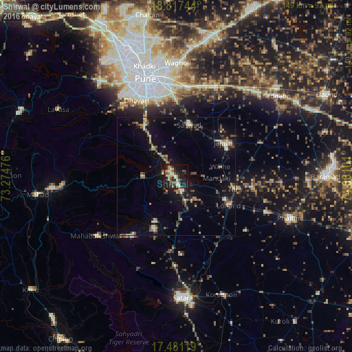
Analysis of Shirwal night lights 2016
Square area 10x10 km:
 0%
0%90-99
11.26%80-89
4.11%70-79
4.11%60-69
6.06%50-59
6.71%40-49
5.63%30-39
4.11%20-29
9.74%10-19
39.83%0-9
8.44%Square area 50x50 km:
0.09%90-99
1.83%80-89
0.92%70-79
1.03%60-69
1.23%50-59
1.79%40-49
1.59%30-39
1.87%20-29
2.04%10-19
9.09%0-9
78.54%Clear (daylight) street map image can be seen on geolist.org.
Map coordinates:
18° 49' 2.8" North, 73° 16' 29.1" East
18° 9' 2.1" North, 73° 58' 40.4" East
17° 28' 52.3" North, 74° 40' 51.6" East
Some cities around Shirwal sort by population:
• Pune
43 km =26.7 mi,  342°
342°
• Wai
23.9 km =14.9 mi,  202°
202°
• Sāsvad
22.2 km =13.8 mi,  14°
14°
• Kharakvasla
38.6 km =24 mi,  326°
326°
• Bhor
14.2 km =8.8 mi,  269°
269°
• Pānchgani
31.3 km =19.4 mi,  216°
216°
• Jejūri
23.8 km =14.8 mi,  53°
53°
• Khed
25 km =15.5 mi, 326°
1256469 (p: 12,703)
Sources (retrieved 2019-11-25):
» Earth at Night: Flat Maps 2012, 2016