Bhor night lights from space
Night Light of Bhor (Maharashtra) from space (India) Src. Average luminocity for 10x10km area is 4.6667% and for 50x50km: 7.4091%.
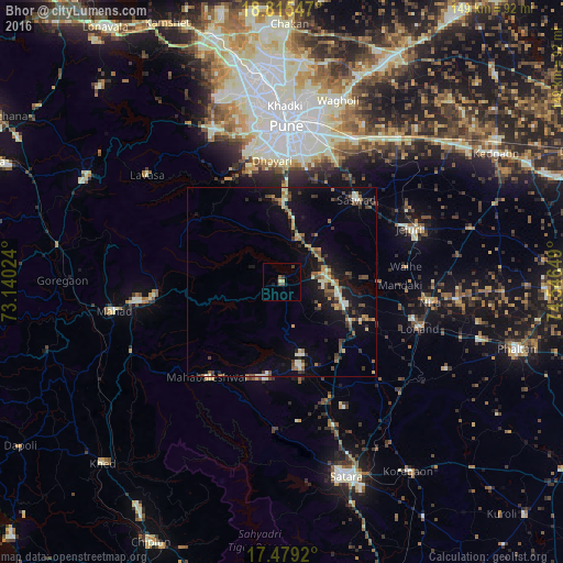
Analysis of Bhor night lights 2016
Square area 10x10 km:
100  0%
0%
90-99 0.87%
80-89 0.65%
70-79 0.22%
60-69 0%
50-59 1.95%
40-49 1.52%
30-39 0.87%
20-29 0%
10-19 1.73%
0-9 92.21%
0%90-99
0.87%80-89
0.65%70-79
0.22%60-69
0%50-59
1.95%40-49
1.52%30-39
0.87%20-29
0%10-19
1.73%0-9
92.21%Square area 50x50 km:
100 0.05%
90-99 1.38%
80-89 0.69%
70-79 0.83%
60-69 0.92%
50-59 1.41%
40-49 1.17%
30-39 1.3%
20-29 1.34%
10-19 6.53%
0-9 84.4%
0.05%90-99
1.38%80-89
0.69%70-79
0.83%60-69
0.92%50-59
1.41%40-49
1.17%30-39
1.3%20-29
1.34%10-19
6.53%0-9
84.4%Clear (daylight) street map image can be seen on geolist.org.
Map coordinates:
18° 48' 55.7" North, 73° 8' 24.9" East
18° 8' 55" North, 73° 50' 36.1" East
17° 28' 45.1" North, 74° 32' 47.4" East
Some cities around Bhor sort by population:
• Pune
41.3 km =25.7 mi,  1°
1°
• Wai
22.3 km =13.9 mi,  167°
167°
• Sāsvad
29.4 km =18.3 mi,  42°
42°
• Kharakvasla
33.2 km =20.6 mi,  347°
347°
• Pānchgani
25.3 km =15.7 mi,  190°
190°
• Jejūri
36.4 km =22.6 mi,  66°
66°
• Shirwal
14.2 km =8.8 mi,  89°
89°
• Khed
21.1 km =13.1 mi, 0°
1275836 (p: 18,982)
Sources (retrieved 2019-11-25):
» Earth at Night: Flat Maps 2012, 2016