Nārāyanavanam night lights from space
Night Light of Nārāyanavanam (Andhra Pradesh) from space (India) Src. Average luminocity for 10x10km area is 25.0744% and for 50x50km: 13.3618%.
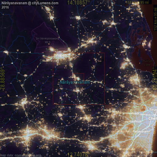
Analysis of Nārāyanavanam night lights 2016
Square area 10x10 km:
 0%
0%90-99
2.27%80-89
5.58%70-79
2.07%60-69
2.89%50-59
7.02%40-49
8.88%30-39
2.69%20-29
2.89%10-19
24.59%0-9
41.12%Square area 50x50 km:
0.49%90-99
2.46%80-89
1.81%70-79
1.17%60-69
1.47%50-59
2.42%40-49
3.35%30-39
3.22%20-29
3.21%10-19
7.04%0-9
73.36%Clear (daylight) street map image can be seen on geolist.org.
Map coordinates:
14° 6' 30.9" North, 78° 53' 8.5" East
13° 25' 32.3" North, 79° 35' 19.7" East
12° 44' 26.8" North, 80° 17' 31" East
Some cities around Nārāyanavanam sort by population:
• Tirupati
29.6 km =18.4 mi,  321°
321°
• Thiruthani
27.9 km =17.3 mi,  173°
173°
• Puttūr
4.3 km =2.7 mi,  295°
295°
• Nagari
11.6 km =7.2 mi,  181°
181°
• Renigunta
26.4 km =16.4 mi,  341°
341°
• Akkarampalle
30.9 km =19.2 mi, 323°
• Narasingāpuram
35.7 km =22.2 mi, 304°
• Pallipattu
18.3 km =11.4 mi,  238°
238°
1261832 (p: 11,432)
Sources (retrieved 2019-11-25):
» Earth at Night: Flat Maps 2012, 2016