Masila night lights from space
Night Light of Masila (West Bengal) from space (India) Src. Average luminocity for 10x10km area is 95.0417% and for 50x50km: 75.1903%.
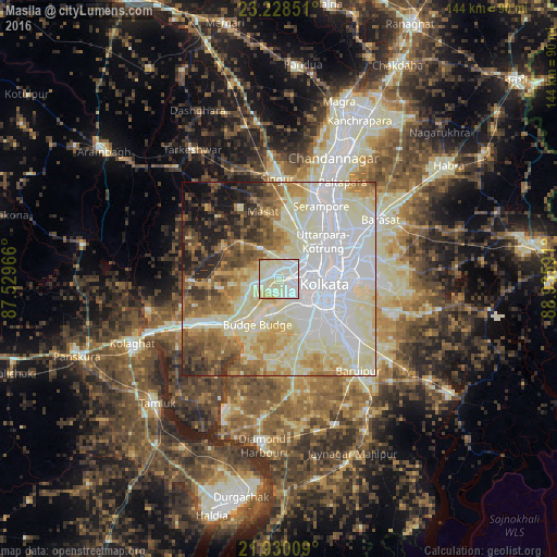
Analysis of Masila night lights 2016
Square area 10x10 km:
 28.98%
90-99
58.9%80-89
10.8%70-79
0.76%60-69
0.57%50-59
0%40-49
0%30-39
0%20-29
0%10-19
0%0-9
0%Square area 50x50 km:
23.14%90-99
25.33%80-89
11.06%70-79
6.26%60-69
7.03%50-59
6.83%40-49
5.22%30-39
4.13%20-29
5.03%10-19
4.75%0-9
1.22%Clear (daylight) street map image can be seen on geolist.org.
Map coordinates:
23° 13' 42.6" North, 87° 31' 46.8" East
22° 34' 51" North, 88° 13' 58" East
21° 55' 48.3" North, 88° 56' 9.3" East
Some cities around Masila sort by population:
• Bankra
5.2 km =3.2 mi,  61°
61°
• Sānkrāil
3.5 km =2.2 mi,  192°
192°
• Dhulagari
6.3 km =3.9 mi,  271°
271°
• Dumjor
4.5 km =2.8 mi,  16°
16°
• Mahiari
0.9 km =0.6 mi, 18°
• Raghudebbati
7.2 km =4.5 mi,  211°
211°
• Santoshpur
7.7 km =4.8 mi,  150°
150°
• Bhandārdaha
5.6 km =3.5 mi,  311°
311°
1348776 (p: 11,461)
Sources (retrieved 2019-11-25):
» Earth at Night: Flat Maps 2012, 2016