Bhandārdaha night lights from space
Night Light of Bhandārdaha (West Bengal) from space (India) Src. Average luminocity for 10x10km area is 80.3883% and for 50x50km: 69.3719%.
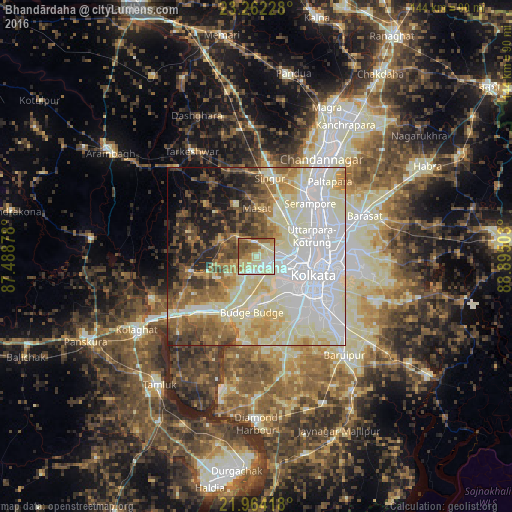
Analysis of Bhandārdaha night lights 2016
Square area 10x10 km:
 9.09%
9.09%90-99
38.26%80-89
13.26%70-79
10.23%60-69
11.17%50-59
11.36%40-49
6.06%30-39
0.57%20-29
0%10-19
0%0-9
0%Square area 50x50 km:
21.19%90-99
21.96%80-89
9.15%70-79
5.7%60-69
6.76%50-59
7.31%40-49
6.07%30-39
4.84%20-29
6.01%10-19
6.63%0-9
4.39%Clear (daylight) street map image can be seen on geolist.org.
Map coordinates:
23° 15' 44.2" North, 87° 29' 19.6" East
22° 36' 53.1" North, 88° 11' 30.8" East
21° 57' 51" North, 88° 53' 42.1" East
Some cities around Bhandārdaha sort by population:
• Bankra
8.9 km =5.5 mi,  98°
98°
• Sānkrāil
8 km =5 mi,  154°
154°
• Dhulagari
4.2 km =2.6 mi,  210°
210°
• Dumjor
5.5 km =3.4 mi,  84°
84°
• Mahiari
5.4 km =3.4 mi,  123°
123°
• Raghudebbati
9.9 km =6.2 mi,  177°
177°
• Masila
5.6 km =3.5 mi,  131°
131°
• Parbatipur
6.2 km =3.9 mi,  30°
30°
1348737 (p: 5,079)
Sources (retrieved 2019-11-25):
» Earth at Night: Flat Maps 2012, 2016