Gurh night lights from space
Night Light of Gurh (Madhya Pradesh) from space (India) Src. Average luminocity for 10x10km area is 24.9444% and for 50x50km: 20.0703%.
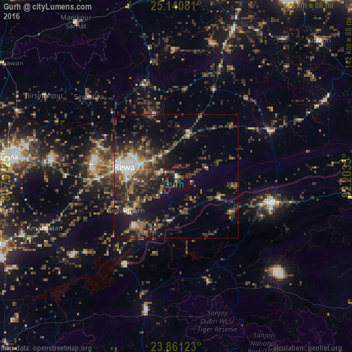
Analysis of Gurh night lights 2016
Square area 10x10 km:
 1.59%
1.59%90-99
1.19%80-89
1.98%70-79
0.79%60-69
0.99%50-59
4.17%40-49
11.9%30-39
5.56%20-29
11.31%10-19
40.08%0-9
20.44%Square area 50x50 km:
1.82%90-99
2.23%80-89
1.43%70-79
1.47%60-69
2.54%50-59
3.75%40-49
5.27%30-39
6.09%20-29
8.78%10-19
11.96%0-9
54.63%Clear (daylight) street map image can be seen on geolist.org.
Map coordinates:
25° 8' 26.9" North, 80° 47' 50.1" East
24° 30' 9.5" North, 81° 30' 1.3" East
23° 51' 40.4" North, 82° 12' 12.6" East
Some cities around Gurh sort by population:
• Rewa
21.3 km =13.2 mi,  278°
278°
• Sidhi
39.9 km =24.8 mi,  105°
105°
• Mauganj
41.9 km =26 mi,  64°
64°
• Chorhat
19 km =11.8 mi,  116°
116°
• Mangawān
18.9 km =11.7 mi,  14°
14°
• Sirmaur
39.6 km =24.6 mi,  339°
339°
• Govindgarh
24.8 km =15.4 mi,  236°
236°
• Baikunthpur
26.6 km =16.5 mi, 339°
1270640 (p: 13,102)
Sources (retrieved 2019-11-25):
» Earth at Night: Flat Maps 2012, 2016