Kuppam night lights from space
Night Light of Kuppam (Andhra Pradesh) from space (India) Src. Average luminocity for 10x10km area is 24.8615% and for 50x50km: 12.1466%.
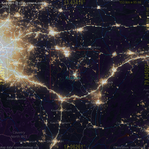
Analysis of Kuppam night lights 2016
Square area 10x10 km:
 0.65%
0.65%90-99
1.95%80-89
3.03%70-79
1.95%60-69
3.9%50-59
3.25%40-49
8.66%30-39
9.09%20-29
9.52%10-19
17.32%0-9
40.69%Square area 50x50 km:
0.37%90-99
1.16%80-89
1.07%70-79
1.04%60-69
1.27%50-59
2.29%40-49
3.74%30-39
3.8%20-29
4.87%10-19
10.38%0-9
70.01%Clear (daylight) street map image can be seen on geolist.org.
Map coordinates:
13° 26' 3" North, 77° 38' 19.6" East
12° 44' 57.5" North, 78° 20' 30.8" East
12° 3' 45.4" North, 79° 2' 42.1" East
Some cities around Kuppam sort by population:
• Robertsonpet
24.1 km =15 mi,  342°
342°
• Ambur
40.9 km =25.4 mi,  83°
83°
• Vaniyambadi
31.1 km =19.3 mi,  104°
104°
• Krishnagiri
29.1 km =18.1 mi,  208°
208°
• Peranāmpattu
45.8 km =28.5 mi,  63°
63°
• Bangarapet
32.2 km =20 mi,  326°
326°
• Jalārpet
32 km =19.9 mi,  128°
128°
• Kāveripatnam
38.8 km =24.1 mi,  200°
200°
1265555 (p: 19,854)
Sources (retrieved 2019-11-25):
» Earth at Night: Flat Maps 2012, 2016