Kulattūr night lights from space
Night Light of Kulattūr (Tamil Nadu) from space (India) Src. Average luminocity for 10x10km area is 3.9048% and for 50x50km: 6.0765%.
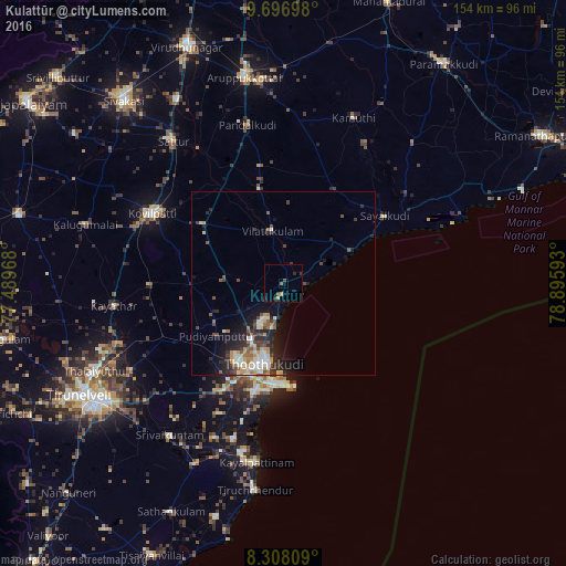
Analysis of Kulattūr night lights 2016
Square area 10x10 km:
 0%
0%90-99
0%80-89
0%70-79
1.52%60-69
0.22%50-59
0.87%40-49
1.73%30-39
0.65%20-29
1.95%10-19
0%0-9
93.07%Square area 50x50 km:
0.56%90-99
1.34%80-89
0.51%70-79
0.91%60-69
0.59%50-59
0.8%40-49
1.1%30-39
0.86%20-29
2.42%10-19
3.68%0-9
87.24%Clear (daylight) street map image can be seen on geolist.org.
Map coordinates:
9° 41' 49.1" North, 77° 29' 22.8" East
9° 0' 11.5" North, 78° 11' 34.1" East
8° 18' 29.1" North, 78° 53' 45.3" East
Some cities around Kulattūr sort by population:
• Thoothukudi
27 km =16.8 mi,  193°
193°
• Kovilpatti
40.1 km =24.9 mi,  297°
297°
• Vilattikulam
14.6 km =9.1 mi,  348°
348°
• Ettaiyapuram
27.2 km =16.9 mi,  305°
305°
• Sāyalkudi
33.5 km =20.8 mi,  56°
56°
• Kayattār
46.4 km =28.8 mi,  262°
262°
• Eral
45.9 km =28.5 mi,  203°
203°
• Pudūr
32.6 km =20.3 mi, 349°
1265740 (p: 10,632)
Sources (retrieved 2019-11-25):
» Earth at Night: Flat Maps 2012, 2016