Kayattār night lights from space
Night Light of Kayattār (Tamil Nadu) from space (India) Src. Average luminocity for 10x10km area is 5.5823% and for 50x50km: 8.6042%.
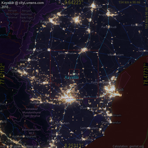
Analysis of Kayattār night lights 2016
Square area 10x10 km:
 0%
0%90-99
0.65%80-89
0.22%70-79
0%60-69
0.22%50-59
0.65%40-49
2.6%30-39
4.33%20-29
0.87%10-19
0.87%0-9
89.61%Square area 50x50 km:
0.56%90-99
1.1%80-89
0.8%70-79
0.89%60-69
1.02%50-59
1.61%40-49
2.34%30-39
2.69%20-29
2.76%10-19
4.54%0-9
81.7%Clear (daylight) street map image can be seen on geolist.org.
Map coordinates:
9° 38' 32" North, 77° 4' 16" East
8° 56' 54" North, 77° 46' 27.3" East
8° 15' 11.3" North, 78° 28' 38.5" East
Some cities around Kayattār sort by population:
• Tirunelveli
26.5 km =16.5 mi,  202°
202°
• Kovilpatti
27 km =16.8 mi,  22°
22°
• Ālangulam
31.6 km =19.6 mi,  252°
252°
• Srivaikuntam
38.6 km =24 mi,  156°
156°
• Kalugumalai
23.6 km =14.7 mi,  341°
341°
• Ettaiyapuram
32.2 km =20 mi,  47°
47°
• Gangaikondān
10.1 km =6.3 mi,  176°
176°
• Elāyirampannai
36.2 km =22.5 mi,  8°
8°
1267357 (p: 10,007)
Sources (retrieved 2019-11-25):
» Earth at Night: Flat Maps 2012, 2016