Krishnapur night lights from space
Night Light of Krishnapur (West Bengal) from space (India) Src. Average luminocity for 10x10km area is 88.4583% and for 50x50km: 74.5426%.
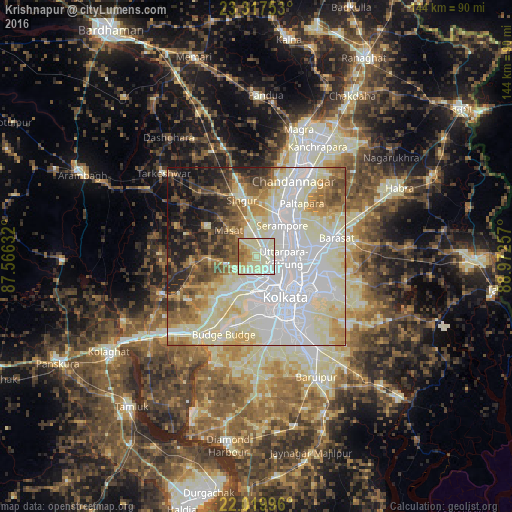
Analysis of Krishnapur night lights 2016
Square area 10x10 km:
 9.72%
9.72%90-99
58.13%80-89
15.08%70-79
6.94%60-69
8.53%50-59
1.59%40-49
0%30-39
0%20-29
0%10-19
0%0-9
0%Square area 50x50 km:
24.35%90-99
25.69%80-89
9.42%70-79
5.86%60-69
6.26%50-59
5.85%40-49
5.41%30-39
4.3%20-29
5.62%10-19
6.55%0-9
0.69%Clear (daylight) street map image can be seen on geolist.org.
Map coordinates:
23° 19' 3.1" North, 87° 33' 58.8" East
22° 40' 13" North, 88° 16' 10" East
22° 1' 11.9" North, 88° 58' 21.3" East
Some cities around Krishnapur sort by population:
• Bāli
7.7 km =4.8 mi,  108°
108°
• Rishra
9.8 km =6.1 mi,  52°
52°
• Konnagar
8.6 km =5.3 mi,  63°
63°
• Bankra
7.5 km =4.7 mi,  173°
173°
• Chakapara
9.2 km =5.7 mi,  117°
117°
• Dumjor
6.1 km =3.8 mi,  203°
203°
• Begampur
6.8 km =4.2 mi,  349°
349°
• Parbatipur
4.9 km =3 mi,  259°
259°
1348742 (p: 7,325)
Sources (retrieved 2019-11-25):
» Earth at Night: Flat Maps 2012, 2016