Kosigi night lights from space
Night Light of Kosigi (Andhra Pradesh) from space (India) Src. Average luminocity for 10x10km area is 2.7619% and for 50x50km: 5.4785%.
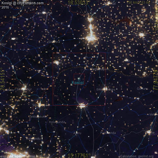
Analysis of Kosigi night lights 2016
Square area 10x10 km:
 0%
0%90-99
0.65%80-89
0.22%70-79
0%60-69
0%50-59
0.87%40-49
0.87%30-39
0.87%20-29
1.52%10-19
1.08%0-9
93.94%Square area 50x50 km:
0.32%90-99
0.81%80-89
0.3%70-79
0.23%60-69
0.79%50-59
1.09%40-49
1.38%30-39
1.29%20-29
1.19%10-19
2.04%0-9
90.56%Clear (daylight) street map image can be seen on geolist.org.
Map coordinates:
16° 31' 49.2" North, 76° 32' 29.4" East
15° 51' 18.4" North, 77° 14' 40.7" East
15° 10' 39.4" North, 77° 56' 51.9" East
Some cities around Kosigi sort by population:
• Rāichūr
40.7 km =25.3 mi,  16°
16°
• Ādoni
25.5 km =15.8 mi,  172°
172°
• Emmiganūr
27.2 km =16.9 mi,  109°
109°
• Sindhnūr
53.1 km =33 mi,  259°
259°
• Gadwāl
72.5 km =45 mi,  54°
54°
• Siruguppa
45.3 km =28.1 mi,  236°
236°
• Mānvi
25.7 km =16 mi,  306°
306°
• Tekkalakote
53.1 km =33 mi,  227°
227°
1266070 (p: 15,455)
Sources (retrieved 2019-11-25):
» Earth at Night: Flat Maps 2012, 2016