Kodoli night lights from space
Night Light of Kodoli (Maharashtra) from space (India) Src. Average luminocity for 10x10km area is 13.4654% and for 50x50km: 14.9357%.
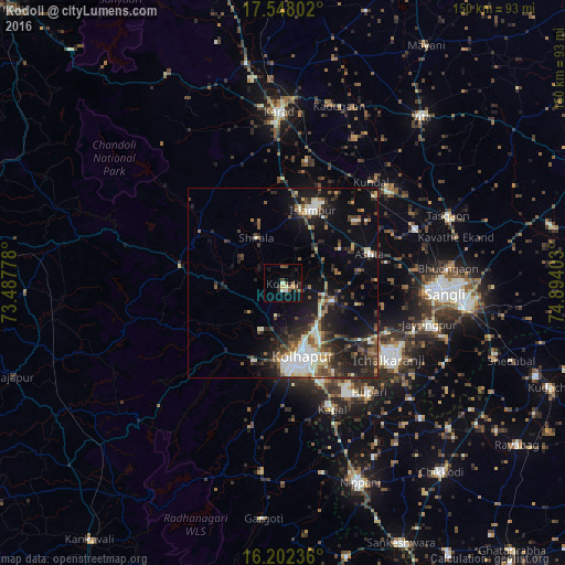
Analysis of Kodoli night lights 2016
Square area 10x10 km:
 0%
0%90-99
3.46%80-89
1.3%70-79
0.43%60-69
0%50-59
4.76%40-49
3.03%30-39
3.46%20-29
1.73%10-19
3.46%0-9
78.35%Square area 50x50 km:
1.51%90-99
2.9%80-89
1.62%70-79
0.68%60-69
1.71%50-59
2.35%40-49
2.57%30-39
2.95%20-29
5.3%10-19
10.41%0-9
68.01%Clear (daylight) street map image can be seen on geolist.org.
Map coordinates:
17° 32' 52.9" North, 73° 29' 16" East
16° 52' 35" North, 74° 11' 27.2" East
16° 12' 8.5" North, 74° 53' 38.5" East
Some cities around Kodoli sort by population:
• Sāngli
39.8 km =24.7 mi,  93°
93°
• Kolhāpur
20.6 km =12.8 mi,  167°
167°
• Ichalkaranji
35.3 km =21.9 mi,  125°
125°
• Jaisingpur
40.2 km =25 mi,  106°
106°
• Ashta
24.6 km =15.3 mi,  70°
70°
• Malkapur
42.9 km =26.7 mi,  357°
357°
• Kāgal
35.8 km =22.2 mi,  158°
158°
• Malkāpur
27.7 km =17.2 mi,  280°
280°
1266390 (p: 17,537)
Sources (retrieved 2019-11-25):
» Earth at Night: Flat Maps 2012, 2016