Karumbākkam night lights from space
Night Light of Karumbākkam (Tamil Nadu) from space (India) Src. Average luminocity for 10x10km area is 19.7879% and for 50x50km: 37.4065%.
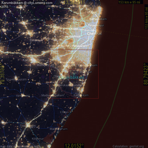
Analysis of Karumbākkam night lights 2016
Square area 10x10 km:
 0%
0%90-99
1.08%80-89
0.65%70-79
0%60-69
0%50-59
0.65%40-49
7.58%30-39
11.69%20-29
17.75%10-19
30.95%0-9
29.65%Square area 50x50 km:
2.47%90-99
7.78%80-89
10.14%70-79
3.87%60-69
6.74%50-59
6.01%40-49
5.17%30-39
4.94%20-29
6.57%10-19
15.68%0-9
30.62%Clear (daylight) street map image can be seen on geolist.org.
Map coordinates:
13° 23' 13.2" North, 79° 23' 16.7" East
12° 42' 7.3" North, 80° 5' 28" East
12° 0' 54.7" North, 80° 47' 39.2" East
Some cities around Karumbākkam sort by population:
• Tambaram
25.1 km =15.6 mi,  8°
8°
• Chingleput
12.5 km =7.8 mi,  264°
264°
• Gūduvāncheri
16.3 km =10.1 mi,  348°
348°
• Injambakkam
29.3 km =18.2 mi,  35°
35°
• Madambakkam
17.4 km =10.8 mi,  343°
343°
• Vandalūr
21.2 km =13.2 mi,  356°
356°
• Seven Pagodas
14.3 km =8.9 mi,  129°
129°
• Singapperumālkovil
11.1 km =6.9 mi,  305°
305°
1267660 (p: 11,992)
Sources (retrieved 2019-11-25):
» Earth at Night: Flat Maps 2012, 2016