Kariapatti night lights from space
Night Light of Kariapatti (Tamil Nadu) from space (India) Src. Average luminocity for 10x10km area is 4.5238% and for 50x50km: 9.9301%.
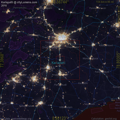
Analysis of Kariapatti night lights 2016
Square area 10x10 km:
 0%
0%90-99
0%80-89
0%70-79
0.87%60-69
0.87%50-59
0%40-49
3.03%30-39
2.16%20-29
1.73%10-19
0%0-9
91.34%Square area 50x50 km:
0.4%90-99
1.04%80-89
0.9%70-79
1.87%60-69
1.36%50-59
1.67%40-49
2.06%30-39
2.44%20-29
2.4%10-19
7.21%0-9
78.66%Clear (daylight) street map image can be seen on geolist.org.
Map coordinates:
10° 22' 2.8" North, 77° 23' 48.5" East
9° 40' 30.2" North, 78° 5' 59.7" East
8° 58' 52.4" North, 78° 48' 11" East
Some cities around Kariapatti sort by population:
• Madurai
27.2 km =16.9 mi,  4°
4°
• Aruppukkottai
18.4 km =11.4 mi,  181°
181°
• Virudunagar
18.5 km =11.5 mi,  237°
237°
• Tiruttangal
36.2 km =22.5 mi,  233°
233°
• Tirupparangunram
23.1 km =14.4 mi,  352°
352°
• Tiruppuvanam
24.1 km =15 mi,  45°
45°
• Kallupatti
26 km =16.2 mi,  280°
280°
• Peraiyur
34.7 km =21.6 mi, 281°
1267745 (p: 14,398)
Sources (retrieved 2019-11-25):
» Earth at Night: Flat Maps 2012, 2016