Peraiyur night lights from space
Night Light of Peraiyur (Tamil Nadu) from space (India) Src. Average luminocity for 10x10km area is 2.7857% and for 50x50km: 5.2238%.
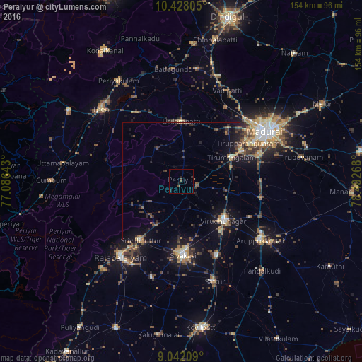
Analysis of Peraiyur night lights 2016
Square area 10x10 km:
 0%
0%90-99
0%80-89
0%70-79
0%60-69
0%50-59
1.73%40-49
0.87%30-39
0.22%20-29
2.38%10-19
2.6%0-9
92.21%Square area 50x50 km:
0.18%90-99
0.36%80-89
0.32%70-79
0.44%60-69
0.56%50-59
1.18%40-49
1.24%30-39
1.36%20-29
1.73%10-19
5.35%0-9
87.28%Clear (daylight) street map image can be seen on geolist.org.
Map coordinates:
10° 25' 41" North, 77° 5' 11.1" East
9° 44' 8.8" North, 77° 47' 22.4" East
9° 2' 31.5" North, 78° 29' 33.6" East
Some cities around Peraiyur sort by population:
• Srivilliputhur
30.1 km =18.7 mi,  214°
214°
• Sivakasi
31.8 km =19.8 mi,  178°
178°
• Virudunagar
24.9 km =15.5 mi,  132°
132°
• Tiruttangal
28.5 km =17.7 mi,  170°
170°
• Usilampatti
26 km =16.2 mi,  359°
359°
• Āndippatti
34.5 km =21.4 mi,  327°
327°
• Elumalai
17.4 km =10.8 mi, 325°
• Kallupatti
8.7 km =5.4 mi,  104°
104°
1259898 (p: 9,244)
Sources (retrieved 2019-11-25):
» Earth at Night: Flat Maps 2012, 2016