Cavelossim night lights from space
Night Light of Cavelossim (Goa) from space (India) Src. Average luminocity for 10x10km area is 30.9793% and for 50x50km: 17.0684%.
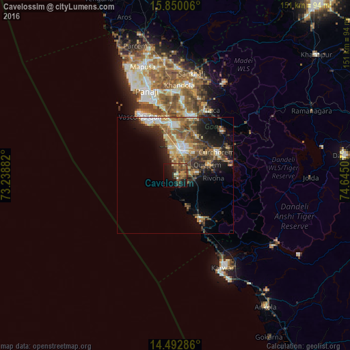
Analysis of Cavelossim night lights 2016
Square area 10x10 km:
100  0%
0%
90-99 2.89%
80-89 2.89%
70-79 6.2%
60-69 4.96%
50-59 9.71%
40-49 10.54%
30-39 6.4%
20-29 4.75%
10-19 24.38%
0-9 27.27%
0%90-99
2.89%80-89
2.89%70-79
6.2%60-69
4.96%50-59
9.71%40-49
10.54%30-39
6.4%20-29
4.75%10-19
24.38%0-9
27.27%Square area 50x50 km:
100 1.32%
90-99 2.71%
80-89 2.03%
70-79 2.26%
60-69 3.4%
50-59 3.9%
40-49 3.45%
30-39 3.01%
20-29 4.72%
10-19 7.51%
0-9 65.69%
1.32%90-99
2.71%80-89
2.03%70-79
2.26%60-69
3.4%50-59
3.9%40-49
3.45%30-39
3.01%20-29
4.72%10-19
7.51%0-9
65.69%Clear (daylight) street map image can be seen on geolist.org.
Map coordinates:
15° 51' 0.2" North, 73° 14' 19.8" East
15° 10' 21.2" North, 73° 56' 31" East
14° 29' 34.3" North, 74° 38' 42.3" East
Some cities around Cavelossim sort by population:
• Madgaon
11.5 km =7.1 mi,  8°
8°
• Cuncolim
5.6 km =3.5 mi,  84°
84°
• Colva
12.1 km =7.5 mi,  350°
350°
• Davorlim
12.3 km =7.6 mi,  26°
26°
• Benaulim
10.3 km =6.4 mi, 351°
• Raia
15.1 km =9.4 mi, 11°
• Chinchinim
5.9 km =3.7 mi,  37°
37°
• Varca
6.7 km =4.2 mi,  1°
1°
1274961 (p: 11,983)
Sources (retrieved 2019-11-25):
» Earth at Night: Flat Maps 2012, 2016