Jetpur night lights from space
Night Light of Jetpur (Gujarat) from space (India) Src. Average luminocity for 10x10km area is 2.7557% and for 50x50km: 3.3083%.
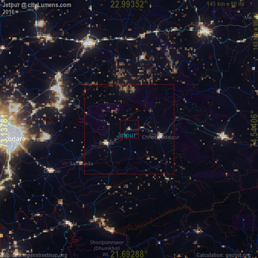
Analysis of Jetpur night lights 2016
Square area 10x10 km:
 0%
0%90-99
0%80-89
0%70-79
0.76%60-69
0.76%50-59
0%40-49
0.76%30-39
0.76%20-29
1.52%10-19
0.76%0-9
94.7%Square area 50x50 km:
0.02%90-99
0.22%80-89
0.25%70-79
0.26%60-69
0.25%50-59
0.67%40-49
0.91%30-39
1.22%20-29
1.71%10-19
1.54%0-9
92.96%Clear (daylight) street map image can be seen on geolist.org.
Map coordinates:
22° 59' 36.7" North, 73° 8' 16.1" East
22° 20' 41" North, 73° 50' 27.3" East
21° 41' 34.4" North, 74° 32' 38.6" East
Some cities around Jetpur sort by population:
• Dabhoi
45.6 km =28.3 mi,  246°
246°
• Hālol
41.8 km =26 mi,  294°
294°
• Chhota Udepur
18.5 km =11.5 mi,  104°
104°
• Devgadh Bāriya
40.7 km =25.3 mi,  9°
9°
• Vāghodia
45.5 km =28.3 mi,  264°
264°
• Sankheda
33.3 km =20.7 mi,  234°
234°
• Kawānt
35.4 km =22 mi,  142°
142°
• Shivrājpur
25.4 km =15.8 mi, 290°
1269064 (p: 8,446)
Sources (retrieved 2019-11-25):
» Earth at Night: Flat Maps 2012, 2016