Hindoria night lights from space
Night Light of Hindoria (Madhya Pradesh) from space (India) Src. Average luminocity for 10x10km area is 14.2143% and for 50x50km: 12.6857%.
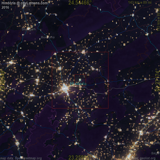
Analysis of Hindoria night lights 2016
Square area 10x10 km:
 0.6%
0.6%90-99
1.79%80-89
1.19%70-79
0.2%60-69
2.98%50-59
1.19%40-49
2.58%30-39
1.79%20-29
3.97%10-19
17.86%0-9
65.87%Square area 50x50 km:
1.17%90-99
1.36%80-89
0.73%70-79
0.85%60-69
1.94%50-59
2.14%40-49
2.41%30-39
3.42%20-29
4.42%10-19
9.24%0-9
72.32%Clear (daylight) street map image can be seen on geolist.org.
Map coordinates:
24° 32' 40.8" North, 78° 51' 55.8" East
23° 54' 12.4" North, 79° 34' 7" East
23° 15' 32.6" North, 80° 16' 18.3" East
Some cities around Hindoria sort by population:
• Damoh
15.1 km =9.4 mi,  238°
238°
• Hatta
25.9 km =16.1 mi,  7°
7°
• Garhākota
45.4 km =28.2 mi,  252°
252°
• Patharia
38.1 km =23.7 mi,  269°
269°
• Katangi
56.4 km =35 mi,  155°
155°
• Shāhpur
52.7 km =32.7 mi, 268°
• Tendūkheda
56.5 km =35.1 mi,  183°
183°
• Bakshwāho
48.1 km =29.9 mi,  323°
323°
1270082 (p: 15,142)
Sources (retrieved 2019-11-25):
» Earth at Night: Flat Maps 2012, 2016