Haldaur night lights from space
Night Light of Haldaur (Uttar Pradesh) from space (India) Src. Average luminocity for 10x10km area is 25.0625% and for 50x50km: 19.9953%.
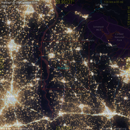
Analysis of Haldaur night lights 2016
Square area 10x10 km:
 0.38%
0.38%90-99
1.52%80-89
1.89%70-79
0%60-69
3.41%50-59
7.39%40-49
7.39%30-39
6.06%20-29
15.34%10-19
40.53%0-9
16.1%Square area 50x50 km:
0.46%90-99
1.31%80-89
1.46%70-79
1.64%60-69
2.7%50-59
3.01%40-49
5.75%30-39
6.53%20-29
8.55%10-19
29.47%0-9
39.12%Clear (daylight) street map image can be seen on geolist.org.
Map coordinates:
29° 54' 4.6" North, 77° 34' 52.5" East
29° 17' 23.6" North, 78° 17' 3.7" East
28° 40' 29.3" North, 78° 59' 15" East
Some cities around Haldaur sort by population:
• Bijnor
17.1 km =10.6 mi,  302°
302°
• Nagīna
22.6 km =14 mi,  40°
40°
• Chāndpur
17.3 km =10.7 mi,  184°
184°
• Dhāmpur
22.1 km =13.7 mi,  84°
84°
• Nihtaur
10.7 km =6.6 mi,  69°
69°
• Nūrpur
19.7 km =12.2 mi,  142°
142°
• Jhālu
7.6 km =4.7 mi,  312°
312°
• Tājpur
24 km =14.9 mi,  126°
126°
1270509 (p: 18,686)
Sources (retrieved 2019-11-25):
» Earth at Night: Flat Maps 2012, 2016