Vagator night lights from space
Night Light of Vagator (Goa) from space (India) Src. Average luminocity for 10x10km area is 57.0022% and for 50x50km: 24.5178%.
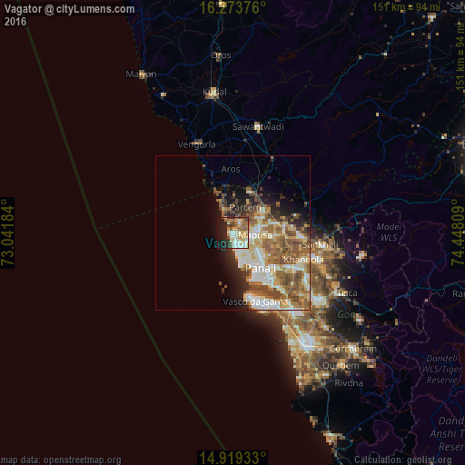
Analysis of Vagator night lights 2016
Square area 10x10 km:
100  6.49%
6.49%
90-99 18.18%
80-89 11.04%
70-79 6.06%
60-69 11.26%
50-59 3.9%
40-49 7.58%
30-39 2.6%
20-29 12.77%
10-19 19.05%
0-9 1.08%
6.49%90-99
18.18%80-89
11.04%70-79
6.06%60-69
11.26%50-59
3.9%40-49
7.58%30-39
2.6%20-29
12.77%10-19
19.05%0-9
1.08%Square area 50x50 km:
100 3.03%
90-99 6.11%
80-89 3.76%
70-79 2.44%
60-69 4.66%
50-59 5.39%
40-49 4.18%
30-39 2.18%
20-29 3.68%
10-19 5.52%
0-9 59.06%
3.03%90-99
6.11%80-89
3.76%70-79
2.44%60-69
4.66%50-59
5.39%40-49
4.18%30-39
2.18%20-29
3.68%10-19
5.52%0-9
59.06%Clear (daylight) street map image can be seen on geolist.org.
Map coordinates:
16° 16' 25.5" North, 73° 2' 30.6" East
15° 35' 51.6" North, 73° 44' 41.9" East
14° 55' 9.6" North, 74° 26' 53.1" East
Some cities around Vagator sort by population:
• Māpuca
6.9 km =4.3 mi,  95°
95°
• Calangute
6.1 km =3.8 mi,  169°
169°
• Solim
3.1 km =1.9 mi,  50°
50°
• Arambol
10.8 km =6.7 mi,  336°
336°
• Candolim
9 km =5.6 mi, 167°
• Guirim
7.1 km =4.4 mi,  110°
110°
• Saligao
6.9 km =4.3 mi,  135°
135°
• Colovale
9.5 km =5.9 mi,  63°
63°
7302453 (p: 14,986)
Sources (retrieved 2019-11-25):
» Earth at Night: Flat Maps 2012, 2016